Call The Lake District Walker on

Search Site

Monthly Archives: January 2011

  • The Bannerdale Round

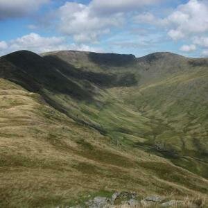
    A good day above Mungrisdale today, although in thick cloud most of the time. Today's route was The Bannerdale Round, covering the summits of Bowscale Fell, Bannerdale Crags and Souther Fell.

    We climbed from Mungrisdale by Bullfell Beck climbing through the heather, and startling a few grouse before climbing the grassy slopes to the summit of Bowscale Fell.

    We were by now in thick cloud and there was very little to see, we followed the grassy ridge to the Bannerdale Crags, a pleasant walk over grassy ground, the route now descended over White Horse Bent to the footbridge over the River Glenderamackin.

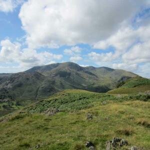
    After a short stop for a few sandwiches we pressed on, climbing the grassy path onto Souther Fell and following the ridge east to the summit.

    We descended the eastern shoulder of Souther Fell to the village of Mungrisdale.

  • Grange Fell and Castle Crag

    A good day climbing Grange Fell from Grange, Borrwdale. We set of at 10am and followed the path through Troutdale, climbing to the summit of Kings How, there were wonderful views from he summit today with only the highest summits in cloud.

    As we descended from the summit of Kings How we spotted a few red deer in the heather, as we approached they ran away but we saw several more as we climbed to Brund Fell, the highest point on Grange Fell.

    From Brund Fell we descended south to meet the main Watendlath to Rosthwaite track and descended to Rosthwaite. After crossing the river we climbed the steep slope of Castle Crag, stopping for our lunches on the grassy slopes before cimbing to the summit of Castle Crag.

    From Castle Crag we descended nor, down to the Derwent River and followed the track back by Hollows Farm to Grange.

  • Haystacks

    A great day climbing Haystacks from Gatesgarth today.

    We followed the path from Gatesgarth climbing to Scarth Gap Pass and climbed to the summit of Haystacks. The views from the summit were great, particularly over the Ennerdale Valley to Pillar.

    After a short stop on the summit of Haystacks to admire the view we continued, descending to Innominate Tarn, stopping out of the wind to eat our sandwiches.

    From Innominate Tarn we continued, descending to Blackbeck Tarn and followed the path over Green Crag, descending by the Warnscale Hut and followed the Warnscale path down to the valley and back to Gatesgarth Farm.

  • High Street

    A misty day climbing High Street from Hartsop today, we set off from Hartsop Village at 10am and followed the track to Hayeswater and climbed the path to The Knott.

    As we climbed above Hayeswater we saw a group of Red Deer grazing on the slope, they seemed uninterested in us as we climbed the steep slope.

    As we approached The Knott we entered the cloud, there was now very little to see so we didn't stop for long on the summit. The easy climb to the summit of High Street along the wall didn't take us too long so we continued to the summit of Thornthwaite Crag, stopping for our lunch out of the wind behind the pillar.

    After lunch we descended the Gray Crag ridge, watching several groups of red deer in the valley below us. As we neared the summit of Gray Crag we emerged from the cloud and were rewarded with good views all around, particularly the view behind us, of Windermere across Threshthwaite Mouth.

    We descended from the ridge to the Hayeswater path and followed it back to Hartsop Village.

  • Silver How - Navigation Training

    A great day on Silver How today with a Navigation Training Course.

    We set off from Elterwater at 10am and climbed onto the Silver How Ridge above High Close and followed the ridge over Silver How and along to Swinescar Pike running several navigation exercises along the way, descending to Chapel Stile by Megs Gill and following the river back to Elterwater.

    A fantastic day with some great views throughout.

  • Scafell Pike

    A good day climbing Scafell Pike from Seathwaite today, we set off from Seathwaite just after 9am following the path by Stockley Bridge to Sty Head. There were several icy patches on the pat, but nothing too bad today.

    From Sty Head we climbed the Corridor Route to Lingmell Col, and from the col to the summit of Scafell Pike, there were a few patches of snow left as we climbed towards the summit of Scafell Pike but nothing we couldn't walk around.  As we approached the summit we saw a glimpse of a Brocken Spectre bend us, it only lasted a few seconds though before it was gone again.

    There was a little cloud blowing around the high tops today, but as we approached the summit of Scafell Pike it blew away giving us some fantastic views all around. Particularly the view of the Isle of Man sticking up through the clouds.

    After eating our sandwiches on the summit we descended north, crossing Broad Crag Col and following the ridge over Broad Crag and Ill Crag before descending through Calf Cove to Esk Hause and down by Grains Gill back to Seathwaite arriving back at Seathwaite a little before dusk.

  • Scafell from Eskdale

    A great day in murky conditions today, setting of from Boot at 9.30 we climbed the ridge by Eel Tarn and followed the path to Slight Side. Just after leaving Boot we climbed into the mist and didn't come back out of it until we were coming back down to valley level in the afternoon.
    The wind, although strong once we were higher wasn't nearly as bad as it had been yesterday and by the time were were on the summit of Scafell there was very little wind. We sat just below the summit cairn and ate our sandwiches before continuing.
    After a quick look at the top of Scafell Crag, with Scafell Pinnacle looming out of the mist we descended by Fox's Tarn, the first scree slope was under snow, but by the time we were down to the tarn there was only patches of snow here and there.
    he gill below Fox's Tarn was very full with yesterdays rain and the snowmelt so we made our way down to the side of the gully to meet the path below and descended by the wonderfully full Cam Spout and down to the Upper Eskdale Valley.
    As we descended by Cam Spout the clouds broke and we were rewarded with wonderful views over Upper Eskdale and up to Esk Pike and Bowfell. The cloud came back in as we followed the track by Silverybield Crag but cleared again as we turned the corner towards the Eskdale Valley, completely breaking as we descended into the valley and walked back to Boot, arriving back just as the sun was setting.

  • Winter Skills

    A good day around Esk Hause today practising some winter skills on the slopes below the pass.


  • Skiddaw

    Another clear day today, this time climbing Skiddaw from Bassenthwaite.

    Setting of at 10am from High Side we climbed the ridge to Ullock Pike and Long Side, the views over the Solway Firth to Scotland were great today and as we reached the summit of Ullock Pike the views to the south opened up over the Lake District.

    We had great views south to Scafell Pike and Helvellyn as we climbed the steep path from Carl Side to Skiddaw. We sheltered just below the summit of Skiddaw to eat our sandwiches out of the cold wind with some great views over Blencathra and the Back O'Skiddaw before we descended north to Bakestall and down to Dash Falls, following the track back to Peter House Farm and the paths back to High Side.

  • Helvellyn

    A good day climbing Helvellyn from Wythburn today, although there was some high cloud the views were exceptional.

    We set off from Wythburn Church just after 10am and followed the main path climbing to the summit of Helvellyn, as we approached the summit a few icy patched made walking a little treacherous, but nothing too bad.

    We stopped in the summit shelter for our lunch before continuing, following the ridge south to the summit of Nethermost Pike and over High Crag to Dollywaggon Pike.

    From Dollywaggon Pike we descended west over Willie's Wife's Moor and down to Dunmail Raise, following the path back down to the woods and back to Wythburn Church.

    Although there was a high layer of cloud all day the views were exceptional with vies to the Cheviots and south past Blackpool Tower to Wales, with Snowdon visible from Dollywaggon Pike!

  • Silver How – Navigation Trining

    A good days Navigation Training on Silver How today.

    We set off from Elterwater and climbed above the High Close Youth Hostel and ran several exercises between her and the summit of Silver How, stopping for lunch just below the summit of Swinescar Pike.

    We continued a little further along the ridge towards Blea Rigg before doubling back and descending by Megs Gill down to Chapel Stile and following the river back to Elterwater.

11 Item(s)

Back to top