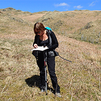


Simon Wallis
Read more
- Home /
- Private Guiding /
- Western Fells /
- Grike
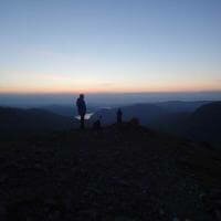
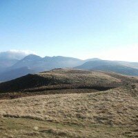
Grike

| Grid Reference: | NY 08495 14076 |
| Height: | 488 metres/1601 feet |
| "Grike is the beginning of Lakeland from the west.." |
|
A Wainwright
|
From the level plains of West Cumbria the land begins to rise, reaching at last the high ground on Grike, the westernmost edge of the Lake District and the terminus of the ridge descending west from Pillar, over Haycock and along the long shoulder of Caw Fell.
The tree lined northern slopes descend steeply to Ennerdale, from where a good path climbs over Crag Fell. To the south and west, barring a few sections of forestry land the ground drops gently over grassy moorland towards the Cold Fell Road.
On the western slopes of Grike lies the Kinniside Stone Circle, an ancient stone circle lying just off the Cold Fell Road.
-
Above Ennerdale to Caw Fell: Private Guiding
£140.00 As low as: £18.00Learn MoreDifficulty:Exposure:Distance: 22km / 14 milesAscent: 990m / 3300ftDuration: 7 hoursMaximum Group Ratio: 10:1A steep climb at times but no exposure, some of the most remote fells in the Lake District
-

Lank Rigg, Crag Fell & Grike: Private Guiding
£140.00 As low as: £18.00Learn MoreDifficulty:Exposure:Distance: 12km / 7.5 milesAscent: 640m / 2100ftDuration: 5 hoursMaximum Group Ratio: 10:1A shorter horseshoe walk taking in three of the lower summits at the western end of the Ennerdale Valley, quiet grassy fellsides and great views over the Cumbrian coast throughout
Shop By
- Price
- Event Type
- Difficulty
-
-
Testimonials
Rating:
A great Easter weekend walking with TLDW! Neil was great, informative and attentive, and we had sun and snow, but always visibility to see the wonderful views. Catbells, Derwentwater, Haystacks and Great Gable were all fantastic!
Paul Mason
Read more Read less
Rating:
I booked the Yorkshire 3 peaks challenge for myself and 4 others, after a terrible booking experience with another company. I told the lady on the phone the issues I had and she gave me great reassurance about this company and the 15 years of experience. I was then given extra reassurance via email. This was great knowing already how much they care about their customers. We started the challenge on the 7/7/18, with Neil leading and Robert keeping everyone at the back together. The ladies in my group found this challenge difficult, but with the wonderful support and guidance from Neil they all completed it and well within the challenge time. Neil went above and beyond with his support, his knowledge and compassion was phenomenal. I just couldn't thank him enough! The whole experience was wonderful from booking to completing. A huge thank you to everyone involved and a special thank you to Neil.
Harriett Renolds
Read more Read less
Rating:
Just spent 2 amazing days walking with the lake district walker. With the help of the fantastic guide, Neil, I completed 2 spectacular walks, the Fairfield Horseshoe and Scafell Pike from Seathwaite. Neil was extremely skilled, knowledgeable and friendly which made the walks even more interesting, fun and safe. I would highly recommend walking with the lake district walker and I will definitely be booking on again soon!!
Lydia Mullen
Read more Read less
Rating:
Helvellyn - a fantastic day out We've been walking in the Lakes for many years, and have conquered some of the higher peaks - Langdale Pikes, Fairfield Horseshoe, but somehow Helvellyn had always eluded us. After a 4 year break from visiting the Lakes we felt that this year would be the time that we had to do it, but weren't sure we could do it on our own. I found the Lake District Walker on the internet and was immediately impressed by the professional website, and the range of walks and events on offer. I booked the Helvellyn trip online and immediately received a confirmation email plus loads of information about the day. When the day came it was so sunny and quite warm, we couldn't believe our luck! Our guide was excellent company, we felt we were walking with an old friend. We're so glad we did the walk with him, he knew exactly the right way to tackle the more challenging parts of the walk. As a bonus, he was also happy to take photos for us with our camera so we have come back with a fantastic record of the day, where we're actually both in the photos, some of which are quite spectacular! We can't wait for our next visit to the Lakes and will be back in touch to arrange the Scafell Pike trip!
Angela
Read more Read less
Rating:
Thank you so much for the amazing walk up High Street We had glorious weather andRachel our guide was a treasure She was friendly ,informative,calm and encouraged and inspired me when I was struggling. Along with two other wonderful members in the group I completed the walk. The views and scenery spectacular and Rachel a gem. The walk was on my bucket list and I have completed it so thank you again you provide a brilliant service.
Gill Sloan
Read more Read less
Rating:
On Wednesday 16/8/17 my son and I joined a group led by Neil (scafell pike walk). Neil was an excellent guide, he knew every persons name and walked a little with each of us. He made the day enjoyable, safe and very rewarding. I hope I can join another group for another great day soon. Thank you.
Andrew Parker
Read more Read less
Rating:
We would like to thank you for the walk yesterday - we all enjoyed it - the route scenery was stunning and a big thank you to Paul who was an excellent guide - friendly very knowledgeable - we could not have done this hike without him - The weather turned a bit on us and we got soaking wet but did not damper our spirits !! We absolutely loved our day - the children absolutely love the experience - Thank you
Nathalie
Read more Read less
Rating:
Did the beginners navi course sunday 8th july leader was tom there was 6 of us all great people we all chatted & had a enjoyable time & learnt a lot of things at a steady pace. Would deffo recommend it & here is to working to get on the next step up
Grahame leech
Read more Read less
Rating:
My two sons and a friend (aged 15 and 12) went Ghyll scrambling in Newlands Valley last week. They had an absolutely fantastic time, all equipment provided, the trip was safe, fun and exciting, I just wished I had done it with them - next time! We would definitely do this again and we would happily recommend! Thank you!
Jayne Straughan
Read more Read less
Rating:
Had a great walk last Monday, Grasmere to high raise. Neville our guide was really good providing snipets of information along the route. I was very greatful for the lone of his walking pole for my sore knee on the descent it really helped. A great days walking
Christine Fletcher
Read more Read less
Rating:
Hi, I would be very grateful if you could please pass on our heartfelt thanks to your excellent guide Neville. He very expertly and kindly helped us to manage the walk up to Scarfell Pike yesterday, encouraging and guiding us when necessary. In particular we would like to thank him for the enormous amount of help that he gave to Paul who found that his legs would no longer carry him on the way down. So please pass on a big thank you from us. Apart from Paul's problems on the way down it was a very enjoyable day with a very friendly and helpful group of people and it enabled us to achieve our ambition of climbing Scarfell Pike safely. Many thanks, Heather and Paul
Heather and Paul
Read more Read less
Rating:
Highly recommended! Due to drive up to the Lakes on Thursday evening, I made a decision on Thursday morning to climb Scafell Pike on Saturday! I came across The Lake District Walker in a Google search and just went for it. I've never climbed a mountain before, and am reasonably fit, but was slightly nervous, naturally. I was greeted warmly by our guides, Alec and Claire, and the rest of our group as we set off. To cut 9 long hours short - it was only due to the friendly and supportive nature of the group, and our guides in particular, did I make it up and down Scafell Pike that day. At times, I cried out of pain and mental tiredness - but each time, Alec and Claire supported me and talked me through it. And they were very candid about what to expect, which is what I needed - the worse thing a climber needs is to be told they'll see the peak around the next corner and then not see it! They are both thoroughly knowledgeable about not only the routes but also on how a novice should approach the climb, so you feel safe.
Anzela
Read more Read less
Rating:
These guys are very helpfull, knowledgable and professional. We had an excellent day and the views were amazing. John (our guide) is such a pro, and I would rellish the chance to walk with him again.
Martin
Read more Read less
Rating:
Hi John, many,many thanks for all your guidance,help,transportation and kindness during the last 3 years while completing my Wainwrights.Everytime it was,in good or bad weather,an experience of a lifetime.I couldn't have done it without your expertise and love for The Lake District.A great compliment to all your other guides as well, Harry
Harry Meijer
Read more Read less
Rating:
Thanks so much to Neil for a wonderful day's guiding Above Whinlatter last Tuesday. Neil was the perfect walking companion - very knowledgeable and professional and seemingly totally happy with taking me - the sole participant - on the walk on a really wet and miserable July day. This is why I book with the Lake District Walker - I'd booked the walk (and all associated train travel to the Lakes from the south of England) some months ago from Australia, and it's great to feel confident that the walk will go ahead as planned and is not dependent on numbers. Unfortunately no spectacular views as the mist & rain closed in, but a fantastic day from my point of view nevertheless. Thanks once again.
Gillian Langley
Read more Read less
Rating:
I religiously climb each year with you and without exception the experience is excellent. Each guide is very well trained , but a common theme is their understanding of the group dynamic and needs. This year climbing Scarfell I was not in best shape so the long descent took its toll... Our guide who works three days a week as an occupational therapist with young people was exceptional and a credit to your team. Thank You Victor
Victor Ktori
Read more Read less
Rating:
Just completed the Coast to Coast with Neil which was a wonderful experience. There were 9 Ozzie’s in our group and Neil handled the diverse group extremely well and dealt with issues far beyond his job description, with us all finally arriving into Robin Hoods Bay as planned. Thank you Neil, your patience and determination to keep us all going was priceless.
Annette Taylor
Read more Read less
Rating:
We did scafell pike on 30th august. We are fairly new to fell walking, only been doing it about 3 months. Our guide was Neil, couldn't have asked for a nicer guide, he was very knowledgable, easy to chat to and looked out for everyone in our group. Our 15 year old son was with us and Neil spoke with him about mountain biking routes too, which my son also enjoys. We were lucky to get with a great group of people doing the walk too. The walk was difficult but so worth it, we were lucky enough to have a lovely sunny clear day and the views were out of this world. We will definitely use district walker again, even when we come back to do scafell pike again, it is worth every penny for the knowledge and safety aspect you receive. Thank you so much. Best wishes Meyrick, Dawn and Cooper Barham
Meyrick Barham
Read more Read less
Rating:
Innes was our guide in the Langdale Pikes walk on 15 September. An intuitive guide, committed to ensuring our 25th Anniversary Walk was the best it could be. Very grateful for the lovely memories- thank you Innes - you were 11-10. No hesitation in recommending Innes.
Howard McCain
Read more Read less
Rating:
Have used this company several times this year - excellent guides, very professional in every respect. Have really enjoyed every walk I've done with them - perfect! I won't hesitate in using them again in the future.
Clare
Read more Read less
Rating:
My first time with TheLakeDistrictWalker. Website easy to use. Reassuring to read all the very good reviews. I am new to scrambling and thought I would start with Striding Edge before hopefully moving on to greater things. Went on Sunday 6 May. There were three other walkers. All good company of a similar standard of ability more or less, to me. John was the guide and led us up the hill often away from the well trodden path, seamlessly taking us up what he knew what was the best route, keeping us entertained with factual information, the features of the views we were looking over, the hills, the towns and rivers we could see in the distance. Being apprehensive beforehand on going up such great height is common. My fears went away on being led across the ridge by someone who knew it. Its really worth the inexpensive fee. The people there without a guide were often making a mess of it, half arete, half path, on their bottoms etc. We went confidently across the entire rock ridge and onto a splendid descent of Swirral Edge and up Catsty Cam. A beautiful sunny day too.
Douglas Rattray
Read more Read less
Rating:
Hi, Great weekend thank you. Please pass on my thanks to all three guides for making it an enjoyable weekend. Many thanks Adrian.
Adrian
Read more Read less
Both my daughter and I thoroughly enjoyed our walk up Lingmell and then on to Scawfell Pike with Neil and the rest of our group. Neil is extremely knowledgeable and kept the group together despite our varying abilities. I have walked with Neil before and he has given me the incentive to attempt all the 'Wainwrights' in the next few years when I can escape work and manage the long drive North from Wiltshire.
Christa Lossin
Read more Read less
Rating:
Excellent day of rock climbing and ghyll scrambling . First time we have done either if these and it certainly pushed us both in fitness and bravery ! John was a brilliant guide and was very patient with us , and we had a great sense of accomplishment by the end of the day . Would absolutely recommend this taster / starter day for anyone a bit mad like us or just looking for a day out in the Lakes with a difference . Also for energetic children or teenagers - they will not stop thanking you if you book them in for this . Many thanks again John and I am sure we will be back for more experiences in the future .
Fiona Taylor
Read more Read less
Rating:
Always fantastic guides I've been on three walks with The Lake District Walker this year. I'm not an experienced walker so started with a lower fell walk in the spring (Steel Fell and Helm Crag), did Helvellyn and Striding Edge in the summer, and Scafell Pike this weekend in the rain and cold! So I've done some more challenging walks and been out in good weather and bad. Geoff and the other guides I've had are all excellent. They are friendly, knowledgeable, always keeping the group motivated and taking care of us all (and, in the case of Scafell in bad weather - getting us all off the mountain in one piece!). There are so many walks to choose from, so you can start with an easier walk and build up to something really challenging. The guides are fantastic for both types of walk. And I can't believe how low the prices are, it's more than worth it. Highly recommend.
Kay
Read more Read less
Rating:
Had another fantastic day out on the Fells with John - an amazing walk up and over The Old Man of Coniston. Really loved all the history and facts that John shared on the way round and can't wait to be back up next year.
Daniel Willmore
Read more Read less
Rating:
We had 2 great days out walking with John. He is always great company and a fount of knowledge of all things Lakes! The second day over Langdale Pikes was especially enjoyable - can't wait ti be back for more!
Daniel Willmore
Read more Read less
Rating:
Hi John Just got back from rock climbing Amazing really enjoyed it I wasn't very good but loved it, Mal an Josh managed to get to the top James was excellent with us all. Thank you for booking it for us and for a great day ghyll scrambling with yourself on Monday Kind regards Yvonne
Yvonne
Read more Read less
Rating:
Hi John What a memorable day Thursday proved on Helvellyn. Thank you very much indeed for taking us along the top of the ridge. Our photos tell the tale spectacularly! It was good to have your expertise and we look forward to joining you in the Lakes again one day. Meanwhile we hope all continues to go well for your business. Best regards, Andrew, Robert and Pete
Andrew, Robert and Pete
Read more Read less
Rating:
Neil was our very patient instructor on Sunday 21st October for beginners Orienteering course - what a useful day spent learning how to read maps, use a compass and understand how to navigate our way around whilst out on the fells - although a lot to take in we feel a lot more confident finding our way around without getting lost! Neil gave us lots of tips and helpful advice and we would recommend this to beginners or anyone new to hiking/walking. A thoroughly enjoyable day thank you Neil Rod & Janice Palmer
Janice Palmer
Read more Read less
Rating:
A big thank you to my guide Neil for a fantastic day climbing Blencathra on 17/07/18. A very patient, informative and encouraging individual especially when assisting me over Sharp Edge!! Thanks also to the wonderful Rachel, who, two days later guided myself and seven great companions up Helvellyn and over Striding Edge and even finding time to fit in Catsty Cam too! I found TLDW to be as efficient now as when I used them in the past, easy to book with, reliable and great to spend a day ( or two ) with!! Regards Neil.
Neil David Hurford
Read more Read less
Rating:
Thank you so much to Jason our guide on our recent Yorkshire 3 Peaks. What a fantastic guy. Really supportive and helpful. Couldn't have done it without him or asked for a nicer guide. Highly recommend.
Kirstie Viner
Read more Read less
Rating:
Did the Yorkshire 3 Peak with LDW and I must say how well organised it was in challenging conditions. Guides were first class and really friendly. Same could be said for the group of fellow walkers. I would highly recommend using LDW for your next challenge.
Steve Arnold
Read more Read less
Rating:
Had an amazing 2 days on the winter skills course. Day 1 beautiful sun in the snow learning basic techniques followed by day 2 in full on wintry conditions. Thank you to John for his quiet calm manner. Really enjoyed the experience and definitely feel more confident with navigation and use of my new equipment.I would not hesitate to book further activities and friends have already asked for recommendations.
Andrea Illsley
Read more Read less
Rating:
So glad we booked LDW to climb up Scarfell pike Al was an excellent guide the weather was horrendous and we would never have found our way up and down without him. He encouraged us and supported us all the way will definitely book with LDW again a great experience and I need to see it with some views next time!
Tina littler
Read more Read less
Rating:
Had a fantastic day with Mark walking Patterdale to High Street. A very long day with heavy rain winds and quite deep snow in places but also a thoroughly enjoyable and rewarding day with fantastic views and a great guide.
Colin Donovan
Read more Read less
Rating:
Great weekend Rock climbing and Ghyll walking in the Langdales. everyone exhausted but vvv happy
mark lomax
Read more Read less
Rating:
Fantastic guided walks I have been out with The Lake District Walker a few times now and they are an excellent company. The guides are all really friendly and very experienced and make the day really enjoyable even in the most trying of weather conditions! They have a fantastic range of walks and will go out even if only one person has booked on. This year my friend and I have scaled Helm Crag, Striding Edge and Scafell Pike and we will be back for many more. We are already avidly looking at the 2014 events! Thank you for making fell walking so accessible, challenging and fun.
Sarah
Read more Read less
Rating:
Thank you Neil for a wonderful day of guiding us over crinkle crags in difficult weather conditions . 50 miles per hour winds but no rain thankfully . We had a wonderful day climbing and scrambling - and it was great to hear your wonderful stories and experience of the local area . Thanks for a great day andrea and Godfrey x
Andrea Hunt
Read more Read less
Rating:
Hi Just wanted to say how much we enjoyed and how useful we found the Beginners Navigation Course with Geoff which we went on last Tuesday 26th March. Having pre booked the day, we had to go despite the weather conditions. However once there we both felt it was probably the best conditions in which to test our navigation skills and my husband called it a “baptism of fire”. It was a bit daunting to see all that snow and not a path in sight. There were 4 of us in the group. I am ok with a map and my husband has done compass work before but as I outlined to Geoff I am losing my confidence in navigating and get a bit panicky that we might get lost even though we have been walking in the Lake District for the last 30 years. Geoff was very patient with us all as a group, offering expert tuition in a friendly but professional manner which we have since put into practice during the rest of our holiday in the Lakes. As a result of this day we will however be buying a new map as our map is quite old, the scale being 1 inch to 1 mile !!!. Thank you. Susan and John
Susan and John
Read more Read less
Rating:
Hi John Would like to say thank you to you and Ross for my 2 day course I feel the knowledge you both got across was excellent and look forward to using the skills in the near future and will definitely look at future courses with yourself and your team.
Chris
Read more Read less
Rating:
Booked the beginners navigation course. James was our guide & we had a fab day which exceeded expectations. James was extremely knowledgeable and the day was fun. Can't wait to book one of the walks!
Audra Mcchrystal
Read more Read less
Rating:
Hello, on May 25th Carolyn and I took on the Yorkshire Three Peaks Challenge along with other walkers. I just wanted to say a big thank you as we would never have done it without you. Firstly, actually booking the date with you made us feel committed and then having a guide gave us confidence and moral support. James was the guide you supplied for this day and may I say, he is an asset to your firm. He's calm, friendly, encouraging, professional and got a good sense of humor ( I hope his mum is proud). He not only looked after his group of walkers but was supportive to others. Had we not have signed ourselves up to take the challenge on with you I think we would have gone home after the first 10 minutes. Instead we completed in challenging weather within the allocated time. Thank you again
Denise
Read more Read less
Rating:
Neil did a fantastic job navigating myself and my daughter over Helvellyn, including Striding Edge and Swirral Edge. My daughter was a bit nervous and Neil guided her every step of the way, making sure she felt safe and encouraged her throughout! We both loved the experience and I couldn't recommend it enough. I will definitely book again on my next trip to the Lakes.
Lynda Longhurst
Read more Read less
Rating:
I recently went on the Pillar and the High-Level route walk, taking in Pillar, Steeple, Red Pike, Scoat Fell and Yewbarrow. This is a fantastic walk with fantastic views all round. Unfortunately the weather on the day wasn't good but it didn't spoil the outing. It is a challenging walk and a long day out but offers just about everything that Fell walking is all about, I thoroughly recommend it.
Terence Kelly
Read more Read less
Rating:
Even though our walk up Scafell Pike was cancelled due to the very adverse weather, John took us on a great walk around Walla Cragg. Booked to try Scafell again at the end of April.
Steve Worswick
Read more Read less
Rating:
Big thank you to Adam for making the walk up Helvellyn and Striding Edge on Sunday good fun. Thoroughly enjoyed the scramble over Striding Edge then onto Helvellyn for views as far as the eye could see. Brilliant day.
Nicola
Read more Read less
Rating:
Had an amazing time on the Pillar walk with Neil as our guide. I would highly recommend this walk, took in some stunning views, and had a real mix of route types to tackle. Hope to book another soon!
Dan Bilton
Read more Read less
Rating:
Hi John just a quick thank you from Holly and Christian who really enjoyed last weeks climbing/walking days. We will be back regularly in Langdale and will certainly use your company again. Regards, Mick
Mick
Read more Read less
Rating:
Three friends and I enjoyed a really great day hiking up from Great Langdale to the summit of Scafell Pike on Good Friday with our guide John. He was calm and knowledgeable, ensuring we felt comfortable with what we doing throughout the day. We would highly recommend him as we definitely would not have reached the summit without his guidance and crampons!
Ashley Young
Read more Read less
Rating:
We wanted to give our three daughters, the love our family has had for the Lakes over the years and their guided walk to the top of Helvellyn along Striding Edge certainly did. It was their first major Fell and it was a very very memorable day for them. This was largely down to Neil who guided a wonderful walk. So a huge thank you to him and the Lake District Walker for looking after our daughters so well from start to finish. You couldn't wish for anyone better than Neil to give them a real classic mountain walk.
Christopher H
Read more Read less
Rating:
The beginners navigation course led by TJ on 15th July was excellent. Small group of friendly people and a fun way to learn pitched at just the right level. I would highly recommend!
Sarah
Read more Read less
Rating:
Morning John I am sorry it has taken me over a week to send this but I just wanted to thank you and Leanda for the help you gave on the recent charity walk we did on Sat 11th June to Helvellyn. All the guides were fantastic giving us all encouragement and guidance all the way. Paul was leading off my group and he was particularly helpful to a couple of members who were a little bit apprehensive and they have since said that they wouldn’t have managed to do it without Paul’s support and expertise. Please can you pass on my thanks - I wasn’t able to do so myself on the day as my daughter was unwell and I needed to quickly get her back to our hotel. We are already talking about doing an annual event which would include a walk and I will certainly give you a call next year if we do so. Many thanks once again. Kind regards Karen
Karen
Read more Read less
Rating:
Hello John Very many thanks for making it possible for me to celebrate my 80th birthday with a trek up Scafell Pike. James was a superb guide, very knowledgeable and informative, helpful and caring at every stage. I found the soft snow section on the third quarter of the climb a bit hard going but the crampons provided for the firmer snow of the final quarter made things much easier. The snow and ice formations were fascinating and beautiful. Despite our earlier fears the weather could not have been more perfect and the crystal clear views of the surrounding peaks in their "winter dress" were stunning. I could not have had a more perfect birthday treat. Do pass on my thanks once more to James. I attach a few photo's including one of sunset reflections in Wast Water as we drove past at the end of the day. Perfect finish to the whole experience!
Richard Baggott
Read more Read less
Rating:
Having benefited hugely from Neil's patience and wisdom as a guide up Scafell Pike last year we decided to go on a beginner's navigation course with him this year. We had a fantastic day out learning a huge amount about maps, compasses and how to observe the terrain around us to find our way. Neil was hugely knowledgeable, long-suffering as we jumped around with our questions, and great fun to be with. We loved it and felt vastly more confident as a result of our day. The next three days' walking around and about Derwent Water were even more enjoyable as as result. Thank you!
Eva Beazley
Read more Read less
Rating:
A big thank you to our guides Rob and Tom for an amazing day climbing Helvellyn/Catsty Cam on 15th June 2024. Weather going up and along Striding edge was horrendous, wind, rain, mist and fog. But both Rob and Tom were patient and full of support especially when our group of 12 had split into 4 smaller groups. Rob stayed with the slower group and Tom went ahead with the faster group. Cant recommend enough TLDW and Tom/Rob. The whole process from booking to competition on the day was efficient and very professional. Thank you.
Modasar Ahmed
Read more Read less
Rating:
Helvellyn my 60th birthday treat! As I have always wanted to climb Helvellyn on the Striding edge route my wife organised a guided walk through Lake District Walker for my 60th birthday. I was very impressed with the guide John who was friendly,professional and gave our group the confidence to tackle this awesome peak. We were lucky to complete most of our climb in glorious autumn sunshine and John's extensive knowledge of the various routes enabled us to reach the summit before the low cloud came in to spoil the views! We also did Catstycam on the way down, a fabulous day which all three of us in the group thoroughly enjoyed. Thanks John .
Jill
Read more Read less
Rating:
Hi John Just like to say what a great time I had on Saturday, Rachel was a really good guide, very enthusiastic, engaging with all the group and managing the pace. I'll be booking again shortly. Thanks Yvonne
Yvonne
Read more Read less
Rating:
Hi John, good morning. I want to thank you for arranging and guiding the walk around Grasmere on Saturday. David and I really enjoyed the walk! It gave me a very good introduction and orientation to somewhere I don’t know at all. I also particularly appreciated your knowledge of the Lakeland poets: I will be doing some additional reading to get a better sense of the background. As I said before, I am planning exploring some more and will get in touch with some ideas (in particular the northern lakes) and possible dates. Have a good week Best wishes Caroline
Caroline
Read more Read less
Rating:
Have walked in Lakes and elsewhere quite extensively - always with social based walking groups . For Loweswater this week - first time with a registered walking company . Very impressed with our guide ( one of your ' Johns ) who despite this not being one of his regular walks was just so well prepared - professional and aware of changing wind / weather conditions throughout the day and totally considerate of our just three in todays group - In a word 'Excellent ' Total confidence so >>> Will now consider an occasional solo away day up to Lakes to walk with a'Lake Disatrict Walker ' Mike J Harrogate
Michaell (Mike) Jones
Read more Read less
Rating:
'STRIDING EDGE & HELVELLYN' with the lovely Rachel! Thank you so much for an amazing adventure packed day and for kindly helping us get to and from the meeting point and hotel. We were feeling apprehensive and nervous about the Striding Edge part of the hike, but Rachel was so reassuring, calm and supportive, we felt very safe with Rachel and thoroughly enjoyed every part of the ridge and scramble! We loved the group company, it was like walking with old friends. Thank you again and we will definitely book another hike with the Lake District Walker when we return! Highly recommend!
Samantha Taylor
Read more Read less
Rating:
I've taken part in several scrambles, walks and climbs with the Lake District Walker team in 2016 and each one has been a great experience. Always professional, always flexible and always delivers a fabulous day out.
Liz King
Read more Read less
Rating:
Today we climbed the highest mountain in England with our very knowledgable guide Arnold. My children, 18 & 16, myself and my two year old hip did something I never thought was possible. Arnold arrived in plenty of time, we met our fellow climbers for the day and began our accent. The scenery was second to none, along with Arnold's knowledge of the area and the whole route. After a short stop for lunch and to add a layer we managed to clamber to the summit. By the time we had climbed to the very highest point in England the rain and clouds and decided to join us too! We descended over the top of the mountain, via a boulder field, in which Arnold was again extreamely good at knowing the best way to cross. Due to me being exhausted and the slowest at walking on the decent we took 8 1/2 hours to complete the walk. Arnold was not at all worried about this and at no point did he or the other walkers make me feel under pressure. This is the most amazing place on earth to walk and see and with Arnold at our side (all three of us) and The Lake District Walker made it possible for us to see this challenge through to a brilliant end. Many thanks
Caroline J
Read more Read less
Rating:
The Crinkles, Thursday 6 June with Alex. A superb day out. Alex is to be highly commended on his knowledge, his caring attitude and his confidence-inspiring ability in all aspects of guiding. He made sure that we got the most out of our day whilst ensuring that no one individual was beyond their ability. As well as The Crinkles themselves, we took in Cold Pike and then had enough time (and energy!) to summit the mighty Bow Fell. Awesome views, when the mist allowed! Will certainly use The Lake District Walker (and hopefully Alex) again for both Fairfield Horseshoe and Striding Edge/Helvellyn. Many thanks, Steve (walked with Michelle & Kath)
Steve
Read more Read less
Rating:
Ok so it wasnt the best of days for views, but well done John for getting us up the Bowfell and Crinkles safely. I cant wait to be back for some more challenging peaks
mark fowler
Read more Read less
Rating:
Many thanks to John, my sister and I had a fabulous day climbing Blencathra and Sharp Edge. The weather was perfect, the views were stunning and the company of our group and guide was fantastic. Will look forward to doing another and wouldn’t hesitate in recommending the Lake District Walker
Emma and Cathy
Read more Read less
Rating:
Another wonderful day on Pillar with LDW. Thanks Neil, always a pleasure to have you as our guide.
Peter
Read more Read less
Rating:
Hi John, you had the patience of a saint when you walked up Bowscales with me last Monday! Thank you for turning out in such grim weather, it would have been easy for you to have cancelled and I am so grateful you didn't. The satisfaction I got reaching the top will stay with me for a very long time. You have given me the confidence to keep walking and the incentive to get fitter. All the very best for the continued success of The Lake District Walker. Amanda :)
Amanda Taylor
Read more Read less
Rating:
Dear John and Lyanda Many thanks for a lovely walk up Scafell and the surrounding area today. Kind regards Cathie and Emily
Cathie
Read more Read less
Rating:
John, Many thanks for organising the guides to take us up Pillar Rock last week. We were very professionally taken up, with minimal fuss and in perfect weather. Many thanks Michael
Michael
Read more Read less
Rating:
Great walk up to Red Screes on Sunday with our guide Simon. The weather was very kind to us and the sun was shining all day. Simon was a great guide and gave lots of interesting facts along the way. Great group of like minded walkers and great views and scenery to enjoy along the way. Looking forward to booking the next one.
Karen Smith
Read more Read less
Excellent day. This is my second event and once again I have had a great day.
Stephen Spooner
Read more Read less
Rating:
I would like to say a big thanks to John and Neil for our two days of climbing and Ghyll walking, and the Helvellyn via Striding Edge scramble. Both guys were extremely good with the kids and us, informative about the lakes and mountains, and nice blokes generally. We felt we were in safe hands throughout all the activities and had two brilliant days out that we shall all remember for years to come. It was all good value for money too and being sent photos, for free, was a very nice touch. We will be recommending you to anyone we know visiting the lakes.
Stewart
Read more Read less
brilliant day winter skills training on helvellyn with john, I would recommend the course to any one wishing to increase their winter experience
kevin schofield
Read more Read less
Rating:
Many thanks for two great days in the Lakeland hills doing my Bronze navigation skills course. The relaxed and friendly approach of learning made the whole experience enjoyable. I feel more confident and now feel happier interpreting maps and using my compass more to better effect. I am keen now to look at doing my Silver stage. Thanks again to John (my patient instructor!). Two completely different days, and today when the mist lifted the views were fantastic. Maybe one day if I can get a bit of experience and looking at getting qualified to lead a group out on the hills I might offer myself as a freelancer!! I highly recommend The Lake District Walker to anyone unsure of which company to use to learn navigation skills.
David Whyte
Read more Read less
Rating:
Big thanks to Andrew who not only waited paitently for 45 minutes whilst we took a detour (by accident) in the car on the way there but also superbly guided us up to the top of Scafell Pike and safely back down. We were unlucky with the weather - thick cloud at the top - so no spectacular view to experience. But we achieved the climb up and back to the carpark - all slightly worn and weathered from the epic walk. I would certainly recommend this company to anyone wanting to do this walk and I would certainly recommend our guide Andrew. Thank you very much for making the day fun for all! Laura
laura
Read more Read less
Rating:
Guide Harry took us up Blencathra via Halls Fell ridge, to give us a taste of scrambling, and then once at the top we took on Sharps Edge. Harry was a great guide and had a calm presence that gave us the confidence to tackle Sharps Edge. Great day and he even turned up early, at our request, as we arrived earlier than expected. Very easy going and overall very easy to organise. I shall definitely use these guys again!
Robert
Read more Read less
John took us Ghyll scrambling @ Newlands on 03/08. Had a great time, thanks John. Enjoyed it so much, going back to do Langdale next week. Stuart/Nik.
Stuart Locke
Read more Read less
Rating:
I went up Scafell Pike from Seathwaite on 21 June 2017. Rachel, our guide, told us the route we were to take and was very informative about the various fells/views en route and we had plenty of breaks throughout.Thankfully the weather was clear on the day and the views from the summit of Scafell were fantastic. Rachel advised us when we needed to be extra careful, such as when scrambling over rocks etc and I was grateful for her advice. I would recommend this to anyone who is not confident in attempting such a walk without a guide and you don't have to be superfit to attempt it. The whole walk was an unforgettable experience.
Mark Dooley
Read more Read less
Rating:
Hi John, I'd just like to say a massive thanks to Neil my guide on Monday 31st July. The young man with us was not able to get onto the ridge of Catbells due to his disability. Neils patience & expertise on getting Johnny as far as we did & back down was astounding!! His local knowledge & history knowledge was something that Johnny very much enjoyed as well as our walk around Derwentwater. See you all soon. Jane
Jane Hall
Read more Read less
Rating:
Hello John. I would like to thank you for making our trip to the Lake District We obviously were a bit ambitious regarding our ability to hike the round in five days but we had a ball. Rick and John were superb guides and we enjoyed their company. The weather could not have been better so the views were superb. It was an experience we shall always cherish. Great memories!
Nick
Read more Read less
Rating:
We walked up Scafell Pike with Ross (don't recall his surnme - tall lad originally from Essex) - we were a group of 3 adults and 3 kids (aged 13 to 11) and he did a great job of taking us up the mountain safely, answering our (probably) silly & naive questions and humoured the kids well. It was a great day and I always felt safe with Ross which for a novice is important when you have kids in tow. He told us stories, pointed out things (like Sellafield way in the distance) and allowed us to do what we wanted to do. I would happily have Ross guide me again and I am so glad I paid for a guide as it made the day.
Steve Rhodes
Read more Read less
Rating:
Great walk up Scafell Pike with Tom as a guide. Helpfully texted us the previous day to confirm arrangements. Started slowly up the valley before climbing up to Styhead Tarn. The group was mixed in age and was paced well. Biscuits at the stretcher box before the Corridor Route to Lingmell Coll. We had the option to do Lingmell but the kids were focussed on Scafell Pike, so that didn't happen. Shame for my Wainwright count but a good day all the same. Stunning views with such a lovely sunny day. The drop down to Sprinkling Tarn was gentle and welcome after a good climb. Back to the cars before dark fall.
Helen Taylor
Read more Read less
Rating:
This is a brilliant, exhilarating experience not to be underestimated by a novice...our guide Phil was amazing so much patience and his guidance was second to none..I would definitely recommend this hike a real achievement.
Louise Dignam
Read more Read less
Rating:
Really enjoyed my second outing with this company completing Helvellyn via striding edge and swiral edge with Catstye Cam as well. Another glorious day weather wise that certainly helped the enjoyment/views. Must admit I enjoyed John's informative knowledge on other walk as our guide on this one was much quieter but no less supportive. Would recommend to friends.
Andrea Illsley
Read more Read less
Rating:
7 Sep 19 - 10 Peaks Challenge. Absolute perfect conditions for the challenge. Neil the guide was extremely friendly, enthusiastic and knowledgeable making the tough walk very interesting. The views were awesome too. Highly recommended and we will definately be back. Thank you.
Phil Whyte
Read more Read less
Rating:
Scafell Pike from Seathwaite Dates: 23 Apr 2016. Just reach the top of Scafell pike it was a great day a bit windy, but warn and when the sun comes through its georgeous and views breathtaking. People always say you can go on your own, but I wanted to go with a guide and a group of people with similar interests. Our guide Neil was really good and knowledgeable and professional at all times, took time to know the group members. Really good group with the same abilities. What a great day, worth the pain sweating and sore feet. Thanks ladies and gents for your company. Looking forward to booking the next trip! This was a awesome experience, could not fault anything, just be prepared it is a long walk over very rough rocky ground.
Vijay Patel
Read more Read less
Rating:
An amazing weekend in the Lakes and what a super walk to the Crinkles and Bowfell. Great Company, John was a fantastic lead for us all, very knowledgable and kept a comfortable pace for everyone. Just booked the night prior, instant confirmation and terrific way to spend a weekend to join like minded people having fun.
Sue
Read more Read less
Rating:
The Buttermere Horseshoe is a strenuous walk over 10 hours! Robbie our guide was excellent being knowledgeable of the walk and identifying all the mountains on the horizon whilst keeping us on time - not an easy task! I bagged my Wainwrights. My thanks to Robbie
Bernard
Read more Read less
Rating:
My second trip with TLDW - this time Lingmoor Fell and Cathedral Cavern. Neil and I agreed that the best Lake District experience is not necessarily always to be found on the highest peaks and fells. This trip was the evidence. A beautiful Spring day - May Day actually - wild flowers, lambs abundant - misty rain pretty abundant too, but only partially and occasionally obscuring the view. Neil was so informed and enlightening - there was scarcely a topic that passed without his cultivated opinion and believe me the topics were diverse - flora, fauna, cultural, social and industrial history, geology, topography, etymology and more. Such a massive contribution to a very enjoyable day. I was delighted to just walk along and absorb it all. Oh, and of course, also enthusiastic, professional, confident and reassuring. Such a memorable day, thank you .
Martin Smith
Read more Read less
Just wanted to thank our excellent guide Paul for his knowledge and calm reassurance when taking us up to Helvellyn via Striding Edge. I was a little uneasy about going along the narrow, jagged ridge before but felt completely safe and in control thanks to Paul. We both felt a sense of achievement and would definitely recommend it as a challenge. Cheers Helen and Laurence
Helen Kirk
Read more Read less
Rating:
Brilliant day weather was superb. Fantastic views all day. Neil was an excellent guide. Will definitely book some more walks in the future.
PETER Bloor
Read more Read less
Rating:
Beginners Course 11/11/18. Neil was excellent in what turned out to be really wet conditions. Patient and providing very clear instructions, we all benefitted from his extensive knowledge. I've managed to "get by" with map & compass over many years, but now feel far more confident in applying the skills more accurately. Would really recommend this to anyone who enjoys walking the fells. Great day, thank you.
Myles Carroll
Read more Read less
Rating:
A fantastic day with Neil on Crinkle Crags. Despite poor weather we had a brilliant walk and I learnt so much. I would recommend the service to anyone who want a great day out. Thanks to all concerned. Nigel McCormick
Nigel McCormick
Read more Read less
Rating:
Rob walked with us Ennerdale Bridge to Borrowdale Very patience with a slow walker that I am particularly through a steep area. Passionate knowledgeable and enthusiastic about his chosen career.Would happily recommended him
Sylvia
Read more Read less
Rating:
Having done Striding and Swirral edge as a 10 year old and not remembering just how exhilarating it is, it was a fantastic day. Now as a 48 year old, I had forgotten how much of a challenge it was. Rick our mountain leader was absolutely fantastic and my wife and I were delighted that we had booked a guided walk. He was supportive and gave us real confidence in making the climb. Thank you for a day that will be long in the memory!!!!!!!!
Richard Adams
Read more Read less
Rating:
Did the Coast to Coast with Neil Davies as our guide/allrounder!! with a group of 9 all aussies and his attention to all of us was awesome he went above and beyond and we all strolled into Robin Hoods Bay happy and elated we had completed the walk all THANKS to Neil
Marion Hovey
Read more Read less
Rating:
Hi John A massive thank you for your brilliant guiding today on our Scafell Pike journey. You were a total superstar. We can't thank you enough for your professionalism, expertise, kindness and encouragement. We also managed to find the pub in Ennerdale, a great recommendation. See you again. Cathie, Chris, Dawn and Franny
Cathie
Read more Read less
Rating:
Ross was our guide up Helvellyn via Striding Edge. The weather was magnificent and brought into view Solway Firth to Morecambe Bay, Ullswater (and beyond) to Wasdale (and beyond.) An alarming number of peaks that each prompted Ross for an anecdote or witty comment or other observation (some serious) to keep the day flowing. He took special care with each of us particularly as we descended The Chimney and ensured he never overlooked or outpaced any of us. This was my first guided trip and thanks to Ros and TLDW it will not be my last. A tremendous day out. Thanks again.
Martin Smith
Read more Read less
Rating:
An excellent days walking up ScaFell Like and Lingmell fell. Neil was an excellent guide who knew his stuff and you felt safe with him leading. He also gave me useful info on going up Helvellyn. Thanks! I would recommend LDW to anyone who maybe unsure about self-guided walking in the mountains or for those who want a tailor made walk.
Stephen Howard
Read more Read less
Rating:
Our group of 4 had a lovely walk up Scafell Pike from Wasdale and back down via Lingmell. We would have come back the way we had came but our guide took us back via a different route (Lingmell) which offered additional and as stunning views over Derwent Water, the surrounding valleys and Wast Water. Our guide Robert was really friendly and very easy company and his dog Otto who he brought along was very entertaining and lovely to have with us also. Robert was full of interesting knowledge about the area and many others areas too which made it really interesting to boot. Thanks so much for a great day. The weather luckily for us was perfect too, not to warm and lots of sunshine we could see for miles at the top.
Katie Barnes
Read more Read less
Rating:
Hi, What a fabulous day Carol and I had yesterday. Neil was a terrific guide, knowledgable, enthusiastic and very caring. He took great care of me near edges and nothing was too much trouble. We had great companions in Mena and Mike who also showed great patience with me and were very easy to get along with. Thank you. The walk itself was magnificent taking in 5 Wainwrights of Pillar, Scoat, Steeple, Red Pike and Yewbarrow. Carol and I were blown away with everything about the day. I would recommend this to everyone and even the nervy ones, like me, get the very most out of their day on the fells with terrific guides such as Neil. We can't thank everyone enough. Brilliant day!
Ken Baker
Read more Read less
Rating:
We did Scafell Pike from Seathwaite with Nev a couple of weeks ago. As a mixed group with differing needs, Nev did a fantastic job of catering for all and we had a fantastic walk and time with him. Great guy, very considerate, knowledgable and clearly excellent guide. Thanks again Nev, we had a great time. Dave (and Pete)
Dave kerry
Read more Read less
Rating:
‘Neil and Rachel were fantastic during our monster 13.5 hour, 20 peak charity walk. From the moment we met at 6am to the point they got us across the finish line they expertly managed our eager front-runners and at the same time bolstered our tired stragglers at the back. They were full of local knowledge and inspired huge confidence as well as offering great value for money. Don’t hesitate to hire these experts.’ Nick Simpson.
Nick Simpson
Read more Read less
Rating:
I just wanted to thank both our guides, Ross and Paul for their excellent guiding this weekend. With Ross, we walked (or should I say climbed) up Blencathra in the pouring rain. I am a cautious soul but Ross was full of encouragement and very careful. He also helped me out in a particular difficult bit (for me) when climbing up a gulley on Halls Fell. We walked with Paul up Scafell Pike, Scafell, Green Gable and Great Gable over 2 days. Blessed with good weather these were excellent walks and Paul was a great guide, very patient and informative and thoughtful about the routes up to the top. Paul gave us invaluable local knowledge about where to start the slog up Great Gable and avoiding having to start from the bottom! Some great experiences and memories - cheers!
Stuart Jackson
Read more Read less
Rating:
Had a great walk up to the top 21 June with small group led by Rachel, she is a great group leader always cheerful!
Dusty Hoff
Read more Read less
Rating:
I did two walks with LDW. The first was the Langdales in awful weather with a great bunch of people. Neil our guide re-routed the walk and we had a fantastic day on Blea Rigg. The second day was much better weather and all went to plan so our small and very friendly group completed 5 peaks from Whinlatter. I thoroughly enjoyed the walks, the company and the expert guiding. I will be booking again and would highly recommend to walkers of all abilities.
Louise Khalid
Read more Read less
Rating:
Joined John and 2 others on my first ascent of Blencathra and sharp edge. Brilliant day, good company and superb weather. After a steep ascent we scrambled up Hall's fell ridge to summit which was a good warm up for sharp edge after lunch. Loved the challenge with John providing excellent tips on route choice plus constantly updating us on the stunning views as they emerged. A pleasant easy descent back to our starting point. Have booked for Hellvelyn and striding edge and can't wait. Would definitely recommend.
Andrea Illsley
Read more Read less
Rating:
Hi john We all had a great time on Saturday! Your guides were brilliant with us.. We raised over £2400 for the challenge so far! Thanks again for keeping us safe Donna
Donna
Read more Read less
Rating:
Thank you Sam Marsland. You are a superb guide, fulfilling you duties more than amply: a true professional. Your knowledge of the terrain, trekking and understanding of human frailties stood you in good stead for helping me complete the trek. I have climbed Mts Snowdon (twice), the Ben and Kilimanjaro (though was too ill to summit), but the terrain at Scafell Pike was unexpected and challenging; I also lacked energy and my mojo had gone AWOL. So I was not in the best shape, mentally or physically to trek up a mountain. But Sam you got all that and with patience, calm and encouragement got me through it. I don’t think I could have scrambled up the ravines without your calm voice encouraging me and strong hands supporting my ankle. So, whilst on Saturday I was struggling, with unlimited expletives flying around in my head and I kept promising myself I would NEVER climb another mountain, today I am looking for which mountain to climb next! And it's a great deal down to you. So thank you again Sam Marsland..... From a very grateful Diksha
Diksha Chakravarti
Read more Read less
Rating:
The Lakeland 3000's 3 day challenge was amazing , exceeding my (already high !) expectations . The routes up were really well chosen, great company , good weather and great guides (perfect combination of good sense of humour and laid back confidence and knowledge ) . Thanks so much John and Ross , I felt really lucky and privileged to be there and am looking forward to doing more .
Clare Jones
Read more Read less
Rating:
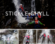
Fantastic afternoon at Stickle Ghyll. Neil was a superb guide and put us all at ease. We were a family of four with a 12yr old and a 10yr old and were the only ones booked on, so had Neil all to ourselves. The facilities at the meeting point were perfect, and easy to park and get changed. Our 10 year old was a bit reticent on the pool plunges, due to the water being so cold, but after some gentle encouragement from Neil, she embraced the challenge and threw herself in. Would highly recommend this to anyone. Such an enjoyable activity, and a change from the standard walking trails.
N Cunningham
Read more Read less
Rating:
Thank you Neil for your expert guiding and a great 10 Peak Challenge day. Despite the weather and sadly lack of views we had a amazing day out. Completed with my husband , eldest daughter and boyfriend we all enjoyed the day and have forgotten about being rained on for most of the time. Neil is knowledgable, very patient and thoughtful , keeping the group together and maintaining good moral and enthusiasm throughout a most memorable day. Huge thank you, until the next time. Mel Rotherham
Mel Rotherham
Read more Read less
Rating:
Thanks for an excellent day yesterday, walking up Scafell and Scafell Pike. A lovely friendly group, amazing scenery and Rachel was a fantastic guide. I especially enjoyed the 'surprise' waterfall scramble :) Aching a tad today! Thanks again.
Lindsey Robinson
Read more Read less
Rating:
Rolo and I have just had 2 wonderfully enjoyable days walking with John and would thoroughly recommend The Lake District Walker to anyone who doesn't have the confidence to venture onto the fells alone. It is a real luxury not to have to worry about the route or your personal safety. I am already looking for the opportunity for another trip to The Lakes. Thank you very much John. Gill lewis
Gill Lewis
Read more Read less
Rating:
I had a great day out with John, wlking from Seathwaite up to the foot of Great End and learning 'winter skills'. The conditions weren't ideal (though not far off!), but John was a great instructor, responding to our needs/wants and managing to find suitable areas for us to learn and practice our skills. I cetainly achievd my aims (learning how to move safely on the snowy fells, using crampons and wielding an ice axe.) I piced 'The Lake District Waker' partly because they loan the necessary kit - so I could try winter hiking before I invest in crampons and axe. It was all great and I really ejoyed the whole day. Many thanks.
Ian
Read more Read less
Rating:
I live in the Lake District now, but instead of walking alone I like to have the reassurance of a guide so that I can enjoy the day exploring fells that I am not familiar with. I have just completed the Langdale Pikes with Rick. It was the second guided walk I have done with him. He is a fantastic guide, relaxed and easygoing. Thank you very much for a very memorable day. I have now completed 32 Wainwrights and I am sure I will use LDW for many more in the future.
Nicky Simmons
Read more Read less
Rating:
We had an excellent day out on the fells with our guide, Tom, who had to re-route for us on the day due to footpath closure as a result of storm Emma a week earlier. It was a great experience all round and we really appreciated the fact that we did not have to look at a map for once but could relax and take in the incredible views knowing someone else was in charge. We would certainly recommend your company to others and consider booking another walk with you when we return to the Lake District.
Pennie Drew
Read more Read less
Rating:
Completed the borrowdale 10 yesterday in amazing weather. It’s a tough walk, with plenty of steep ascents & tricky descents & scrambling over rough ground & boulders at times. But the views were amazing, the group very friendly & our guide Neil very knowledgeable, calm & patient. It’s quite an achievement but don’t underestimate it!
Susan Simpson
Read more Read less
Rating:
I would like to pass on my thanks for such a memorable weekend My first visit to The Lake District and thanks to Neil one to be cherished. Neil made the weekend with his expertise and patience as well as lots of local knowledge. I will definitely be back Many thanks and kind regards Annette
Annette
Read more Read less
Rating:
My friend and I attended the Beginners Navigation course 13/1/19. Neil provided clear instructions and was encouraging throughout. I would recommend this course to anyone who seeks to be more confident and self reliant in the fells. Many thanks for a super day Neil. (Despite the weather)
Christine Napier
Read more Read less
Rating:
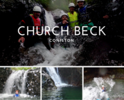
Thank you my 10 year old granddaughter and her friend loved the Ghyll scrambling at church Beck Coniston
gail batten
Read more Read less
Rating:
Really enjoyed our first walk up Helm Crag and Steel Fell on Saturday 30th June. Thanks to our guide TJ who was very knowledgeable and good company. Will definitely be trying another one.
Tracey Hayes
Read more Read less
Rating:
I started walking with The Lake District Walker in June 2017. Having now undertaken a total of 12 walks with them, I can honestly say all have been great walking experiences. I've been guided by Mark, Rachel, Neil, Paul and John all of whom have been professional, friendly and knowledgeable. On every walk, I have felt in very capable hands, particularly when the clouds have descended, the winds are blowing at 40 mph plus and the rain was lashing down. I've recently discovered the joys of proper winter walking using crampons and an ice axe, scrambling through knee deep snow and being buffeted by icy winds only made getting to the top of Coniston Old Man more of an enjoyable challenge. I have met some engaging fellow walkers, as part of the groups - really diverse in life and walking experiences, and good company too. It has been interesting how many of them are repeat bookers with TLDW. John and his team are excellent organisers and TLDW offers a great way to experience some of the best walking in the Lake District. One of my tasks over the Christmas break is to plan my TLDW schedule for 2018 - I've already bagged a place on the 24 Peak Challenge in May. Wishing John and TLDW team a very Happy Christmas.
David Braysmith
Read more Read less
Rating:
Many thanks John, for a great morning canyoning in the Langdales on Friday. Age range was 12 to 50 and all coped well with the scrambling. Water was low (out of your control) so not too challenging and the pools were good fun to dunk in! Will definitely be in touch about doing it again. Tony
Tony Bray
Read more Read less
Rating:
Beginners navigation course on Sunday 9th September was really good. Our guide Neil was very patient with us novices and I’m looking forward to getting out in the mountains with a map and a compass!
Lesley Oakenfold
Read more Read less
Rating:
A huge thank you to Phil our guide. He was extremely knowledgeable about the geography of the area and was super encouraging when I was anxious about cross striding edge. Without him I definitely wouldn't have made it. Our group was also great! See you on the next hike Phil!
Beverley Simon
Read more Read less
Rating:
At very short notice the lake district walker team organised a private guide for the Seathwaite route to Scafell Pike including Lingmell and Great End. Claire our guide was excellent and my son George also benefited from some free Geography tutoring en route! A great day out and a highly recommended route - much more interesting than the slog up from Wasdale in my opinion.
Jonathan
Read more Read less
Rating:
Just to say thank you so much for an insightful two days. It was an amazing course! On Monday, I wore a groove in Nanny Lane on the way up and down to Wansfell Pike while practising my pacing. On Tuesday, I went to Grasmere and up to Lang Howe, Silver How, Dow Bank and back to Grasmere. And I was almost overcome with emotion that every blobble I walked to, fitted the map. And I didn't get lost once, thanks to your teachings. No precipices, no crags, it was all very easy underfoot. I have to admit, I was averaging only about 1km an hour, double and triple-checking etc., but with more practice, I will learn to trust myself more and get quicker. And anyway, the view is there to be admired.
Cecilia
Read more Read less
Rating:
Hi John Just a quick thank you from us for a very enjoyable walk on Saturday. We plan to come up again towards the end of the summer & I will give you a call. Kind regards Martin
Martin
Read more Read less
Rating:
A fantastic day where, under the tutelage of the lovely Neil, we successfully & safely made it to the summit of Helvellyn after scrambling the infamous Striding Edge. Neil was brilliant with his knowledge & skill of the area and his encouragement was fantastic in getting our small group of 4 safely back to base after reaching Birkhouse Moor, Striding Edge, Helvellyn, Swirral Edge and Catstycam. A brilliant day and look forward to booking more with LDW. Thanks again, Neil!
Emma Lawson
Read more Read less
Rating:
Hi, I went up Blencathra on Wednesday 2nd Aug with Peter & a lovely lady called Jerry. We may not have got to Sharp Edge due to the grotty weather, what we did do was Halls Fell & the summit. Please pass on my sincere thanks to Peter, it was a challenging & slightly nerve racking day, he made it an amazing experience & made me feel completely at ease all times. Thank you so much for ticking off one on my bucket list & I will be back to do it again in the sunshine. Take care, Allanna
Allanna Lakin
Read more Read less
Rating:
Hi John, I just wanted to thank you, and your guides, Rick and Hugh, for an amazing day on Saturday. The guides were perfect, the route was amazing and the kids thoroughly enjoyed themselves. The weather was on our side, the views were spectacular, we all had a fabulous day. The kids enjoyed the climbing sections and were up front all the way. They didn't moan once and I think they enjoyed it so much as the route was varied, so thank you. In fact they are keen (as are we!) to do another. Would you have any suggestions?
Emma
Read more Read less
Rating:
Hi. My mate (Lee) and I hiked to the summit of Helvellyn, via Striding Edge (and down Swirrel Edge), last Thursday (26/04/18) with a small group and TJ as our guide. The hike was fantastic. A proper Lake District experience. Striding Edge was, as expected, both terrifying and exhilarating. We also had proper Lake District weather, four seasons in one day (and yes, that does include snow). The group of people also gelled really well which made the experience all the better. Thanks for a great day...
Joe Devlin
Read more Read less
Rating:
We enjoyed an amazing day walking up Blencathra and Sharp Edge. Everything ran smoothly and our guide was extremely knowledgeable and entertaining. We loved our stay in Keswick, but this day was definitely the highlight of our visit to the Lakes District. We can't recommend the experience highly enough.
Marlene De Martin
Read more Read less
A wonderful day climbing Helvellyn via Striding Edge in winter conditions before descending via Swirral Edge. Thank you to John for leading the three of us so skilfully. I shall remember this walk for a long time to come.
Marcus Chapman
Read more Read less
Rating:
I did the Lakeland 3000's 3 day challenge. To be able to do the 3 highest peaks in 3 days was a great challenge which I thoroughly enjoyed and guides John and Ross were brilliant. The weather, the chosen routes and the company was perfect. Looking forward to doing more walks with The Lake District Walker.
Sarah Wixon
Read more Read less
Rating:
A really enjoyable walk and not too demanding. Good leadership and good company.
Richard Cyster
Read more Read less
Rating:
As a novice we recently undertook the beginners navigation course. We had a good day learning how to use a compass, map reading and make use of the sights around us. It was a fun and mentally challenging day as i struggle with differentiating my left from my right! Paul, our guide was incredibly patient with me as I seem to have my own particular logic in understanding the natural landscape and points of a compass! I would recommend this to anyone who wants to feel more confident when out for a walk or thinking of going on the fells. We put our new found skills into use throughout the rest of the week in the Lakes and we didn't get lost once!
SARAH MANUEL
Read more Read less
Rating:
What an amazing day. Helvellyn via striding edge and back down swirral edge. Neil was our guide for our group of five. Absolutely brilliant. The weather wasn’t great at times so we got the full Helvellyn experience but he was quietly in control at all times. If you are even slightly thinking about doing this day just do it! You won’t regret it!
Sarah Maddison
Read more Read less
Rating:
After many years of visiting the Lake District and various climbing trips I finally took the plunge and with the expert guidance of Neil and the company of three group members climbed Helvellyn via Striding Edge And Swirral Edge on a wet and very windy day in October. A great experience which was made totally uncomplicated and enjoyable by the advice, knowledge and patience of our guide. Not only was a long held ambition to tackle Striding Edge fulfilled, but I also managed to tick off three Wainwrights and add 1000 metres to my Everest Anywhere challenge. I am already looking at next year's programme of guided walks to add to my 2020 target.
Philip Richardson
Read more Read less
Rating:
Had a lovely walk with Andy, he is a great guide. Thank you so much, we will definitely use you again. Cathie and Emily xx
Cathie and Emily
Read more Read less
Rating:
Hi John. Thank you for a excellent day of navigation on Sunday August 13th. Colin and i really enjoyed it! We both learned so many new skills. The course was absolutely perfect with weather to match. Great group of people helped us to enjoy the day further. Will definitely be booing the advance navigation next. Many thanks once again for a informative and enjoyable day. Phil
Phillip Sampson
Read more Read less
Rating:
Thank you Rachel for leading a wonderful sunny climb up Scafell yesterday. You were an excellent guide for our group. The scenery, company and sunshine made it a perfect day.
Fran R
Read more Read less
Rating:
Hi just wanted to thank Ross for guiding us up Scafell Pike on 30th Sept. In particular he dealt expertly , calmnly and with reassurance when I tripped close to summit . He expertly did some first aid and enabled me to continue to the summit. His knowledge of the area was also much appreciated . Will recommend you to others . David
David Ellison
Read more Read less
Rating:
Olly/Jane 20th June , scafell pike, great day out with Alex as our guide, he knew his stuff, had a good laugh with the rest of the group(8) weather got better and better and got some great photos,a mix of different abilities in the group but Alex kept everyone happy, well worth the money, thanks again
graham allman
Read more Read less
Rating:
Really enjoyed the walk up Scafell Pike on Saturday 27/10. Weather was brilliant but what made it an even more enjoyable experience was Paul our guide. He was patient and encouraging through the toughest parts of the walk. Would highly recomend
Catherine Penn/David Penn
Read more Read less
Rating:
The only way to go..! Early in the year I decided that Scafell Pike needed to be climbed and so booked with Lake District Walker thinking that perhaps a guided climb would be the sensible way to go. Arrived at the meeting point with my son and daughter on what was a truly wet and miserable Saturday morning. Because of the terrible weather other groups were calling off but our guide Geoff and the others in our group were up for it. The weather was so lousy and visibility so poor at times that, had we not had a guide, I think I'd still be on that mountain. Being part of a mixed group was great, making for a memorable shared experience. The climb itself was not at all easy and I was glad that we'd put some training in before hand, although Scafell's rather martian terrain and the weather on the day, we just could not have prepared for. All in all very challenging but equally very rewarding. Highly recommend using The Lake District Walker as I would not have wanted to do this, particularly with conditions as they were, alone. Highly recommended.
Mike
Read more Read less
Rating:
John, was first class on my recent Great Gables walk. Extremely knowledgeable about all things to do with the Lake District. Our route was well thought out to include as many great views as possible. A lovely touch was the point John lead us to for lunch, overlooking the Wastwater valley, magnificent - and usually missed by most people who lunch at the peak of GG.
Paul Richardson
Read more Read less
Rating:
After our first attempt at Helvellyn and Striding Edge was abandoned 7 years ago, and the fact that I am not good with heights, we decided to have a guide for this attempt. We met our group at Glenridding and our guide Paul. He briefed us as the weather forecast was not good and asked us regarding any concerns he should be aware of. We started our walk. An enjoyable ascent, with plenty of history and anecdotal information from Paul. When we arrived at Striding Edge the clouds cleared, the wind dropped and the sun came out. Paul planned our traverse and was brilliant. He managed to keep me confident and my fears at bay. He assisted me (and the group down the chimney) with foot and hand holds in the rock. He gave me that reassurance that my fears required and got me and the group safely through Striding Edge. We successfully reached the top of Helvellyn and was down the craggy rocks on the other side, heading round the Tarn before the weather hit us with hailstones, thunder and a bit of lightening. I would like to thank Paul for getting me through this climb and would recommend a guide for Striding Edge (TLDW). Thank you, would not have done it without you. Dawn
Dawn Gaforg
Read more Read less
Rating:
Thank you to our guide, Ricky for a fantastic day on Helvellyn, taking in Striding Edge, Wirral Edge and Cats Eye Cam. I felt at ease, took in the amazing views and thoroughly enjoyed my scrambling experience, under the watchful eye of Ricky. There was no pressure to scramble and other options were provided, but I am so glad I did! Many thanks Ricky.
Gail Jackson
Read more Read less
Rating:
Did the snowdon crib-goch walk 3/6/17 with Simon,really enjoyed it,weather was a mixture of good and Bad but mostly good,Simon was really helpful and really mixed with the group(5 on time and 2 really late but Simon did his best for the missing 2 but they didn't appear)he was giving tips and advice all along and kept the group together,myself and the wife(Jane) are doing scarfel pike next Saturday with them,hopefully it will be just as entertaining
graham allman
Read more Read less
Rating:
Good morning John. Just a quick email to pass on my thanks for the course I attended with James on Friday. James is a real asset to your company. The knowledge and information he passed over was very beneficial, and will assist me in reading maps and providing me with the confidence to go further afield on my own. Thank you once again for fitting me in at short notice. Regards Nigel Bailey
Nigel Bailey
Read more Read less
Rating:
I joined a walk of Helvellyn via striding edge with a small group in June. It was such a fantastic walk - I grew up in the area and have done a fair amount of walking in the lakes but by far this is the best I’ve ever done. Incredible views in all directions and I enjoyed the slightly technical requirement of going over striding edge, felt like a proper adventure! Our lead Paul was very knowledgeable and it was lovely to hear historical insights about parts of the landscape we walked through. Highly recommend.
Nicola Brown
Read more Read less
Rating:
I just wanted to thank your company and James for making it possible for me to climb the three peaks I had set as my goals. James was quietly confident and showed lots of patience. I wish him well ...he sounds like he knows where he wants to go! And hopefully I will come back in the near future to do lots more. Kind regards Beena
Beena
Read more Read less
Rating:
My son loves walking and wanted to do Scafell Pike. A little nervous we Phoned The Lake District Walker. They were so helpful in arranging our trip. So we met John and I intrusted him with my family . They had fun and John was so kind to my daughter Becky. Thank you for helping then fufill a dream . John you rock
Lisa
Read more Read less
Rating:
My son and I had a fantastic day climbing The Langdale Pikes. We booked to join the scheduled walk and as it turned out we had John all to ourselves. Without going overboard the day was marvelous. The weather was perfect and the snowline began just above Stickle Tarn. my son bounded up and down the mountain but I was a fair bit slower and less confident. John was with me all the way, introducing us to crampons and ice axes at just the right time. Being unfamiliar to the area, joining The Lake District Walker meant I didn't have to concern myself with map reading, or worry about any safety aspects. In addition we got a taste of the expert knowledge that John has of the area, it's geology and history. I can't think of a better way to enjoy the mountains and look forward to joining The Lake District Walker on our next visit.
Brett Radley
Read more Read less
Rating:
I had a great day out with Ross on the Langdale Pikes and Pavey Ark. It ended up as 1:1 which was a real bonus. Lots of interesting conversation and Ross was happy to share his knowledge of the area. Fantastic value for money and I will certain book Lake District Walker when I return to the Lakes next year.
Sue Lewis
Read more Read less
Rating:
A group of 7 unhealthy lads decided to do a charity sunrise climb on the 27th of February 2016. John was such an amazing guide. From organizing the event until the end of the climb he was really helpful! John had a lot of patience with us and always had a smile even when we moaned. He gave us enough breaks and even though most of us wanted to quit, he made sure we got to the summit! One of the trekkers from the group dropped his phone which slid down the mountain, John went out of his way to slide down the mountain to rescue the phone. He bought his own camera and captured great shots for us as non of us wanted to take our phones out as it was really cold! He even sent the pictures within an hour of us finishing the climb (I did repeatedly ask if he ever sleeps!) was a real good experience and i would definitely be using John again.
Faheem Dharma
Read more Read less
Rating:
Loweswater Fells 2nd February 2016. It was a blustery, grey day when we set off. It did get more blustery as the day wore on and although the sun came out, it didn't shine where we were! It was frustrating watching it in the far valleys, but it didn't rain!! After the previous few days that was a result! It was a super walk, but I would have enjoyed it more if I'd not been full of cold and generally feeling under the weather. Not the fault of the team guiding us. The other walkers in the group were lovely and I was made to feel very welcome as I was on my own. The top of the fells were very exposed to the wind and both my dog and I were struggling by the second peak and were happy to head back slightly earlier than the rest of the group. I was given very clear and accurate instructions as to how to return to the car park. I also knew that the group would only be half an hour behind me on the descent. I would recommend the Lake District Walker. The guides are knowledgeable and for me, it was fun being able to walk in company. Sometimes doing walks on your own all the time gets a bit dull. The dog's conversational skills are somewhat limited! Hope to be back for another trip soon.
Emma Colman
Read more Read less
Rating:
Hi Please pass on many thanks to Rob and Ellen for a great 2 day course and their infinite patience and knowledge. Kind regards Rachel
Rachel
Read more Read less
Rating:
Totally brilliant walking weekend over Easter. Had a great time, walking to High St. from Patterdale on Saturday, and Striding edge on Easter Sunday. I'll never forget the beautiful winter images of snowy Striding Edge. Can't praise Neil and John enough for their skill and professionalism!
Rob Turner
Read more Read less
Rating:
AMAZING climb up Scafell Pike on a glorious day (23/5/18) which gave me the best views possible. Tom was our guide. There was only 3 of us but he made sure that we all stuck together with our range of ability. It's an arduous climb after Styhead tarn and relentless. But the sensation of accomplishment and the views are just spectacular. This is the first time doing an LDW guided walk and I will definitely be booking to do another when I am in the Lakes. Another Wainwright achieved!
Angie Anderson
Read more Read less
Rating:
My friend and I attended the Beginners Navigation course 13/1/19. Neil provided clear instructions and was encouraging throughout. I would recommend this course to anyone who seeks to be more confident and self reliant in the fells. Many thanks for a super day Neil. (Despite the weather)
Christine Napier
Read more Read less
Rating:
Had a great day ghyll scrambling with John. Was fun, thrilling and was taught interesting facts about the local area! Would highly recommend.
Charlotte Fabi
Read more Read less
Rating:
Hi John, I really just had to write and let you know how much I thoroughly enjoyed the Snowdon Horseshoe walk last Saturday. The last time I attempted Crib Goch two years ago the weather was dreadful and we backed off, but last Saturday conditions were perfect. I particularly wanted you to pass on my thanks to Owen for leading this walk so well. Apart from him pointing the way I didn't find any of the scrambling difficult and enjoyed every minute. He is a thoroughly nice chap, knowledgeable and easy to talk to and get along with. I would really hope that I can walk / scramble with him again sometime (and your good self of course). Best wishes, Frank.
Frank
Read more Read less
Rating:
Robert was a great guide, easy to walk with, and we managed to complete all three peaks in just over ten hours! Would really recommend, our group size was just six, we started at 8am at the car park in Horton and got back before sundown. It was a fantastic day!
Kate Griffiths
Read more Read less
Rating:
What a great day, great walk and great guide. Alex was our leader full of great knowledge and advice on what started as a tricky walk in the rain and mist. He kept us all going and laughing all the way and even managed to book the sun for us when we hit the summit.The walk down with the views was spectacular something I will always remember and treasure.
Suzanne Howell
Read more Read less
Rating:
Took my Dad on navigation course with Ross, really good, both enjoyable and educational. Thanks
David Barnes
Read more Read less
Rating:
A big thank you to Harry for guiding us on our maiden fell walk (Wansfell from Ambleside) on Sunday. We absolutely both loved it. Harry was the perfect guide. Not only very, very knowledgeable but also his love for Lakeland shone through. We were so inspired we even ventured to the top of Garbarrow Fell from Aira Force on Monday ! We will be back without a doubt. Thanks again Harry. Gary & Joanna Swinney
Gary Swinney
Read more Read less
Rating:
Enjoyed an excellent 2 day winter skills training course which has given me the technical knowledge and confidence to get out on the Fells in snow conditions. Excellent local terrain knowledge by the instructor, John, who gave us some very good practical and theoretical training in regard to trekking and surviving in snow conditions. I would strongly recommend this course to anyone wishing to gain knowledge and experience in winter conditions. I certainly would not have attempted to go out in this type of environment without having undertaken this excellent course.
Peter Aggett
Read more Read less
Rating:
Thank you Paul, for listening to what we thought we could do - testing our skills then carefully challenging us further. You did this in a supportive way; always ensuring we were comfortable with our understanding We feel much more confident - but couldn't remember where we parked the car at the end of the day - we may need a top up soon!!!
Joanne Thornhill
Read more Read less
Rating:
John. Thanks once again for a great day out. The weather was a challenge at times and I'm sure my own personal lack of fitness gave Jack a bit to think about. He was excellent on the day. Like James before, a credit to you to pick such good young mountain leaders. Very safe. Attentive. Prepared. Great local knowledge. I have enjoyed hiking to Scafell twice in the last 6 weeks, with my daughter and my fiancée TLDW. Successful days thanks to two very good guides and your company. I would not want to tackle SP without them! We will be back this year. I spoke to Jack about an idea for a trip with a group of grads from my company. Will be in touch. Thanks to you and Lyanda personally from me for looking after us. Regards. Dan
Dan
Read more Read less
We had a fantastic day yesterday walking up from Tarn Hows to Black Fell and Holme Fell. The views were stunning and the help and support given by TLDW was superb. It was a very interesting route with some beautiful views and a day we will always remember. Thanks to TLDW.
Nigel and Marion McCormick
Read more Read less
Rating:
A big thank you to Neil for helping two 50 year-old first-timers get to the top of Scafell Pike (and back!). The walk was challenging but really enjoyable thanks to Neil's patience, encouragement and local knowledge.
Mark & Fiona Farrow
Read more Read less
Rating:
Really grateful again for excellent guiding in beautiful places . I did the Welsh Walking Weekend in quite good weather (for Wales!... meaning winds up to 80mph precluded Crib Goch(definitely a good call! ) ). Rob, our guide was kind, thoughtful and encouraging to all the group and his confidence was such that I felt able to play and free range on the scrambly bits of Tryfan and the Snowdon Horseshoe whilst feeling safe (a perfect scenario ) Ellen's assistance on the Tryfan day was an added bonus. I have been so impressed by this company ..thank you . Clare
Clare Jones
Read more Read less
Rating:
Just a great big Thank you to John at the lake district walker & especially to Rik & Ross for providing us with 2 epic days out on sucessfully completing The 24 Peaks in 24 Hours.. 2 great lads with huge knowledge & stories. Definately come highly reccomended. We wish you all well with your futures..
Ian Chapman
Read more Read less
Rating:
Just a very quick note to express our appreciation for the great day out we had with Aled. He was thoroughly professional, very friendly and got us to Scafell Pike and back down again with a broad smile on our faces. We will definitely be back for more !!
Tony
Read more Read less
Rating:
Thank you for such a lovely walk up Castle Crag. I would never have done it on my own. I learnt so much about the geology and history of the area. John was so calm and gave me the confidence I needed. Paddy (spaniel) enjoyed it also. Thanks so much. Will book again soon. Marion McCormick
Marion McCormick
Read more Read less
Rating:
Hi John I'd just like you to know what an awesome day I've had with my guide Dale doing Striding edge/Helvellyn! His knowledge was fantastic & although I was very anxious scrambling over striding edge, I felt totally safe with Dale! Fantastic day. Jane
Jane
Read more Read less
Rating:
Thelakedistrictwalker was easy to reserve, their communication was immediate and useful. We did the Coniston Old Man walk today and our guide was Neil, he was really good and good company. Today was so good that we are deciding on our next walk in the lakes with this company.
Philip King
Read more Read less
Rating:
Hi there, Just wanted to say thank you to Fay for a great day out on a very busy Scafell on Saturday. We had a really good day and thought Fay was very professional and pleasant; she also coped really well with our very mixed ability group and kept everyone safe and happy. Many thanks, Frankie and Steve - Scafell Pike Saturday 19th April
Frankie
Read more Read less
Rating:
The best way to see the high points of the lake district. Like a previous reviewer I wanted to see the best and highest points of the lake district, but felt uncomfortable going out on my own as the conditions can change quickly. I signed up for two different tours, Scafell Pike and Great Gable. The guides were incredibly knowledgeable and I felt both entertained and well looked after. On the first trip we were a group of 5 with various levels of skills and on the second trip which took place in quite harsh weather it was only me. I would strongly recommend using the company and will myself do so again. It is a great day out and the price is more than reasonable.
Peter
Read more Read less
Rating:
Myself and a group of friend completed Ben Nevis with you guys last weekend, great day so thanks John for that.
Nathan
Read more Read less
Rating:
Hi John many thank's for the great time I had on the Lakeland 3000s challenge,although the weather was not to good the three days walking made trip up from Suffolk well worthwhile,the guides are great the scenery brilliant. Ken
kenneth leggett
Read more Read less
Rating:
We all really enjoyed our walk with Ricky. Patterdale to Great Knotts had great views, saw the rounding up of the Herdwicks from the fells and the ongoing flood repair works. I wish Ricky the best of luck in his new ventures and will join him for a walk in Scotland very soon.
denise sykes
Read more Read less
Rating:
Wow what an amazing experience we had climbing to the top of Scarfell Pike this weekend. John was an excellent guide who was full of interesting facts we felt in very safe hands. This was the best spent money this year I can't recommend this little gem of a company enough ! Thank you Caroline and Kevin
Caroline and Kevin
Read more Read less
Rating:
Thanks John for a fab day out in very tough conditions up on High Street. 4 well earnt wainwrights and some red deer thrown in for good measure
Rachel
Read more Read less
Rating:
Thank you to John for an amazing afternoon Ghyll scrambling at Newlands. We all thoroughly enjoyed the sliding, jumping and scrambling. You took us all out of our comfort zone and the adrenaline was flowing. However, thanks to you we all felt safe and well looked after through out. We will be back! Thanks again - Karen, Rachel, debs, Maria, Helen, Lou and daredevil Abby!
Karen
Read more Read less
Rating:
Hello, I just want to say a massive thank you to Ross for yesterday, he knew how important it was to me to get to the top and he made sure we did it. He made us all feel completely safe and we had 100% faith in him that if anything was to go wrong he would be able to deal with it. He is a credit to your company. He kept spirits up when we had all seriously had enough and we can't thank him enough.
Holly
Read more Read less
Rating:
Hi John, home now after our few days in the Lakes. I just wanted to let you know how much we all enjoyed our day with you on the navigation course. You pitched it perfectly giving us lots of opportunity to practice. We all learnt lots and Chorley and Kinley loved it, as did Paul - so a great result. Thanks so much. Shame the weather wasn’t great for your day off this week. Hope to see you again, winter course maybe. Thanks again John best wishes Gail
Gail
Read more Read less
Rating:
Great guided walk up Blencathra. Thanks John. Really informative about not just the routes. But all the local views, wildlife etc that we would have totally missed out on if we'd just tried it ourselves.
CS
Read more Read less
Rating:
My son and I were part of a small group (just 3) to be taken up to Scafell Pike from Seathwaite by Rachel. We were very lucky to have very good weather - cold but clear. The trek was harder than I expected (I may have chickened out if I'd have known) but Rachel was calm and encouraging so we completed the walk in the expected time. Very glad we did not attempt this without a guide - some places would have been tricky and there are points at which it's not easy to see the route. Very proud of ourselves for having done this challenge and would use The Lake District Walker again. Next trip - Helvellyn via Striding Edge!
Sharon Aitken
Read more Read less
Rating:
Great introduction to Ghyll scrambling. went with three sons ( aged 17, 15 and 10)- there was enough challenge for all of us, without anyone feeling 'out of their depth'. Great fun - all equipment provided and was of good quality. Great value and would thoroughly recommend.
Mark Woolcock
Read more Read less
Rating:
A big thanks to John, Hugh, James and Jeff for helping our group of 30 complete the Yorkshire 3 Peaks on Saturday. Everyone had a great day and really enjoyed it and I know that the last group who completed the the challenge were extremely grateful to you guys, especially Hugh, for helping them get through it, even though there was only limited time left in the day to complete it. All the members from TMfit Personal Training Studio send their thanks and best regards to you all!
Tom
Read more Read less
Rating:
Excellent day guided by Neil on Striding Edge, Helvellyn and Catsycam. Thoroughly recommend both the route, and especially Neil as a guide. Many thanks.
Calum Cassie
Read more Read less
Rating:
Hi what a great walk today .Shame about the weather. Bill was brilliant kept us all going and safe perfect guide
Simon O’Donnell
Read more Read less
Rating:
I just wanted to say how much our group enjoyed our trip up Blencathra and over Sharp Edge yesterday. Andy was absolutely first class as a guide and looked after us very well. Many thanks and best wishes Jim
Jim
Read more Read less
Rating:
Scafell pike from Seathwaite on Wednesday 03 August. Thanks to our guide Armold for his patience and cheerfulness despite the torrential rain and 50mph winds and for getting us to the top and back safely. Arnold was unperturbed by the weather but made appropriate changes to the walk to keep us safe. We had a great day out - thanks! Karen and Jane
Karen Crossley
Read more Read less
Rating:
So I have decided to take up hiking and as a young boy I did a lot of hiking in the lakes. I booked through the lake District walker and our guide was Ross he was amazing definitely a asset to your company. I am planing to come up next month and twice a month after that I am hooked. Thank you for a amazing day and thank you Ross your a star hope to see you on my next hike fella keep living the dream...
stephen hamer
Read more Read less
Rating:
I joined the hiking group to Scafell Pike on 7 Apr and Rachel was our mountain leader. Rachel is very friendly and patience with the entire group members, and made sure everyone remains in her radar. We all managed to walk to the peak albeit with challenging snowy paths, and the team mates were supportive to each other. A very nice day out overall!
Chee Teik Ong
Read more Read less
Rating:
Excellent walks during Easter with Neil. Great Gable was challenging but we were rewarded with fantastic views in great conditions. The Crinkle Crags walk was curtailed due to high winds and relentless rain but, as I was the only walker, I had a bonus navigation lesson! Am now much more confident when looking at a map which is massive progress for me. Am looking at the navigation weekends next! Louise
Louise Khalid
Read more Read less
Rating:
My daughter and I thoroughly enjoyed our group trek with John to the summit of Scafell Pike on Sunday, 19 September.
Kath Hannabus
Read more Read less
Rating:
I joined the team at elterwater for beginners map reading and navigation skills Met by Ian and Corrine From the outset I knew this would be a great day We split into two teams and from the off Corrine was on a mission and at the end I was surprised as I had learnt skills life skills in a simple and easy manner My our team was chatty and all engaging So if looking for a great day out and to learn a number of skills sign up as you will love it
Lee Goodwin
Read more Read less
Rating:
Hi, a massive thank you to Neil who took my dad my two sons and myself scrambling up Church Beck Ghyll last Thursday we all had a fabulous time. Neil is very experienced and knowledge of the area and ensured we all had lots of fun. Delighted to recommend to anyone of any age and we will definitely be coming back for more adventures ! Jason
Jason
Read more Read less
Rating:
Just a quick message to say that the walk was great fun. I was impressed that my guide Rick was able to arrive on time even though the traffic was madness due to a race taking place in the same location. The walk was broken down into easy to manage segments and I felt very confident throughout the walk. I had been nervous about the drop that everyone spoke about. However, I followed the footsteps of the guide with ease. I really enjoyed myself and will be booking Rick for my next walk in the lakes. My dog, Koda enjoyed the walk and then we went to the Keswick Ghost Walk to work up an appetite for our pub dinner. It was a great day out. Many thanks Rick!
Denise
Read more Read less
Rating:
A huge thank you to John our extremely knowledgeable, patient and friendly guide that took us on our walk from Seathwaite oop yonder hills to the summit of Scarfell Pike and back again safe and sound on Saturday. We throughly enjoyed the walk of our lives! John constantly give us snippets of local info that was informative and very interesting. We definitely would of struggled to complete that walk without our expert guide leading the way. We recommend The Lakeland walker guided walks highly and hope to return again and partake in another climb in the future, hopefully with John at the helm. Again many thanks. David & Hana
David Nieuwenhoff
Read more Read less
Rating:
A huge thank you to John for 2 great days in the fells - Bowfell and Crinkle Crags - dead icy and cold but fab views and John's knowledge of each fell helped me to picture each one. Lingmoor Fell and Side Pike the next day were also fab - managed 'fat man's agony'!! The Little Langdale Mines were really interesting too! Thanks again John had a really lovey break and look forward to more walks over Easter. Cath
Catherine Bates
Read more Read less
Rating:
A big thank you to James for guiding us up to the summit of Scafell Pike. He was very tolerant of my slow progress and made the walk interesting for my 9 year old son by adding in some extra scrambly bits for him.
Paula Whysall
Read more Read less
Rating:
Completed the Yorkshire 3 Peaks on 7 September in a little over 10 hours, although both physically and mentally challenging, this personally would not have been achieved without the superb guidance received from our guide Robert. Highly recommended experience and made for an enjoyable day for our group size of 6. Keep up the good work Team! Melissa Thomson
Melissa
Read more Read less
Rating:
Thoroughly enjoyed the climb with our guide John. As a novice climber John took all the stress out of the climb and I was able to really enjoy the day without having to think about which way to go or using a map or compass. He also pointed out different points of interest and the whole day was very relaxed. I'll definitely book again. Thanks
Vaughan Daly
Read more Read less
Rating:
A weekend of walking in the Braithwaite and Newlands area. Have been several times with LDW so knew I'd get a good service. 3 of us on the Copeland walk Saturday and despite hailstones and rain we got clear moments . Our guide, Miles gave us lots of snippets of information along the way and we ended in the pub so a result! Sunday was just me and Paul who is an expert guide. At times, the wind almost knocked me over and Paul checked and re-checked I was OK it was all added to the amazing views and breathtaking walks. Approximately 30k in the bag overall!
Linda
Read more Read less
Rating:
Had an excellent day walking up Helvellyn with Paul via Striding Edge .. although 3 of our group were nervous about the ridge Paul was excellent and guiding us all the way. His knowledge and expertise was second to none. The views were amazing and worth the hard work and determination to do the ridge. Cant wait for the next one.
Karen Smith
Read more Read less
Rating:
Thank you, John, Ross and Rick so much for all the support given to me on my recent 2 week holiday in early April 2016. All the walks I did were absolutely excellent from Helvellyn & Striding Edge, Wetherlam, Caudale Moor and Skiddaw, to the beginners Navigation Course and the Ghyll scrambling. Thank you all for making all those activities possible for me to do as I was on my own. My confidence has really grown. I will definitely be back. Many thanks Jane Cregeen
Jane Cregeen
Read more Read less
Had a fantastic day doing Bowfell and the crinkles on Tuesday 21st march. John was very informative as we walked up to the crinkles. The views were fantastic the pace was very good. I will certainly be booking for another walk in the near future 10/10.
Stephen Wood
Read more Read less
Rating:
I had a fabulous day out walking with Rick on Tuesday, amazing weather, and exactly the sort of distance and pace that I wanted. Brilliant. Rick was punctual, and an informative and easy friendly guy to spend the day with - So all good.
Sarah
Read more Read less
Rating:
Climbed Scafell Pike today with my daughter and a lovely group of lady hikers, including our fabulous guide Rachel. We had a wonderful day and Rachel expertly guided us all up and down, with much knowledge, confidence and care (including encouraging me over the most challenging parts of the climb). I cannot believe what great value this guided day was! Worth absolutely every penny and so glad we found The Lake District Walker. We'll be back. Thanks for a truly brilliant day Rachel and fellow walkers!
mary dalby
Read more Read less
Rating:
What an excellent three days of walking Three County Peaks. I was very impressed with the relaxed approach of the guides; this made me feel under no pressure to rush or be of a certain standard to join the walking group. I particularly wish to say a huge thank you to Rachel who guided me over Striding Edge to Helvellyn, and Old Man of Coniston. She is super friendly, always had a smile on her face, offered so much information about the environment and areas on each walk, always knew exactly the right spot to stop and catch your breath, and she enabled me to feel confident walking over Striding Edge for which I am truly grateful !! Wonderful times, thank you.
Maria Hutchings
Read more Read less
Rating:
A big thank you to Jess for leading our walk to Scafell Pike from Seathwaite. Had a great mixed group. She showed interest in all of us and we all had a great chat with a walk thrown in. Made sure we all kept together and all got to the top even though mixed abilities. Everyone was as happy for others to get there as they were for themselves as got us to bond together. Extremely hot day and not sure we would have got up or down without her as couple of dodgy sections, especially on the corridor where she made sure we all got down safely. Special thanks for bringing jelly babies
Matt Smith
Read more Read less
Rating:
Hi John FYI Peter was a very good guide, he took us up a great (scenic) route to the top, we got very lucky with the weather and had some excellent views. Many thanks again for arranging, we had a (unexpected) great day on Scafell Pike Kind regards Rob
Rob
Read more Read less
Rating:
We have just walked Helvellyn with Ross. A great day, the weather was kind, Ross was patient, and encouraging. I wouldn't have made it without him. We will be booking more walks soon.
Heather McCarthy
Read more Read less
Rating:
Just wanted to say how fantastic our walk up scafell Pike was! We had such a great day. Our guide, Tom was just awesome! He was very knowledgable, calm & fun - managing a mixed group brilliantly. Hope to do more walks with you guys soon.
Louise
Read more Read less
Rating:
Had the most amazing experience on the Scafell pike walk yesterday with John and my fellow walkers plus Libby the gorgeous Labrador.It was probably the hardest thing I have ever done.....no it was the hardest thing I have ever done! But wow the pride and sense of achievement will last a long long time. John was marvellous ,sympathetic to the needs and abilities of all the party and very knowledgable about all things Lake District.Thanks again
Steve Fryer
Read more Read less
Rating:
Hi John We had a Fabulous day today , thanks and huge thanks to a very attentive interesting guide.. Attached some of the photos.. It was Tonys 70th birthday today and he thoroughly enjoyed this walk.
Bev Wade
Read more Read less
Rating:
Hi, just wanted to say thanks for an amazing walk up blencathra today we both loved it. Thanks, Louise and lee
Louise and Lee
Read more Read less
Rating:
Hi, We just did a walk today with John and wanted to feedback what a great day out it was. We were booked on the Steel Fell and Helm Crag walk, but were a little concerned about our capacity, but as we were the only three on the walk John took us on an alternative walk which we just loved! After today none of us would hesitate to book walks through you guys again. Once again - a day which started off with us feeling uncertain and faced with uncertain weather, turned out to be our favourite day walking so far. Giovanna
Giovanna
Read more Read less
Rating:
Had 2 fabulous days completing the Lake District 24, 2 long but exhilarating days led by Neil and Rachel who were both superb, professional, kind and knowledgeable. Our 3rd day was slightly easier navigation training with James who was incredibly patient. A great 3 days spent in the Lakes and I would certainly endorse this company and hopefully use them again in the future.
Nicola Godin
Read more Read less
Rating:
Big thank you to Paul who took us on the Fairfield Horseshoe walk this weekend. Very knowledgeable and a really nice guy. Lovely walk, didn't expect the sunshine as everyone we usually do rains so had a lot of coats in the rucksack. I'm booked in for hellvelyn and striding edge on the 20th Oct, hopefully I will see Paul again then. Thank you x
kirstie whyatt
Read more Read less
Rating:
29/07/19 Did Scafell Pike via Seathwaite. A big thank you to Jack McNeive for been our wonderful expert Guide for the day. Such fantastic views and company along the way. I would recommend LDW to anyone without hesitation.
Jean Leese
Read more Read less
Rating:
Many thanks to your company and Rachel the course leader, for the basic navigation training day, just before Easter. A superb day, with great weather, good company and a skilled course leader; who took my knowledge of map reading and compass usage from 0 to capable in just a few hours. . Not to mention the unexpected inclusion of my first Wainwright! A fab course, for great value, which has left me with the skills I need to go wandering by myself in the great yonder....;;0). Thank you.
Kelly Eaton
Read more Read less
Rating:
Had a fantastic walk this weekend (on the Fairfield Horseshoe), led by Paul ,who was very friendly and knowledgeable. The sun shone all day, hardly any wind and the views were spectacular. Will definitely be back for more! Nicola Brown
Nicola Brown
Read more Read less
Rating:
Thanks to John's expert guidance, our group: Sharon, Melanie, Graham and me had a wonderful day on Blencathra and Sharp Edge 1/7/17. The weather was kind to us, and we managed to safely reach the top of the challenging Sharp Edge, before the rain and mist arrived. Fiona
Fiona Taylor
Read more Read less
Rating:
Lovely pictures, but so much better when you're really there! Thanks for a great day John & James
Liz
Read more Read less
Rating:
Alex was our guide for the yorkshire 3 peaks walk on saturday 13 of july this year great job in keeping us motivated and getting us to the finish with a great group on the day thanks for making it a fantastic experience cant wait to do the next challenge with you guys thanks again jon xxx
Jon edmondson
Read more Read less
Rating:
We joined a group walking up Scafell Pike on Saturday 11th August and loved it! Scafell is not easy at all, quite strenuous for a large part and some of the terrain is very difficult, but it's worth it! The view from the top is amazing if you're lucky enough to get a clear day. This trip was easy to book, and the information given was clear. We were provided details of the meet point as well as directions and a list of equipment we needed. Our guide, Hugh, was extremely friendly, professional and knowledgeable and put us at our ease. I felt a little intimidated at first as some of our group were clearly experienced walkers and my husband and I were not nearly as fit as they were, but Hugh (and everybody in the group) were encouraging and friendly and made the day a great success. Thanks Hugh. Just do it, book a tour and go climb Scafell. It's worth the effort!
Mary
Read more Read less
Rating:
Brilliant day out with John on the winter skills course. As well as a great day out with an instructor who was so informative, we now feel better equipped and confident to venture out in the snow. Thank you.
Sarah Chalmers
Read more Read less
Rating:
28th Feb 2016 - This is one to recommend - Days just do not come much better than this. So thankful to John for an amazing day up Helvellyn, White Side & Raise from Legburthwaite. Fantastic view throughout the walk, together with ice climbers, skiers and mountain bikers. 35 years since being on top of Helvellyn and a first experience with crampons and ice axe. Cheers Tom
Tom
Read more Read less
Rating:
Dear John and Neil, Thank you so much for the best walking holiday! I loved every minute, i'm still capitalising from the experience. Fairfield Horseshoe, Pike O'Blisco & Cold Pike and Helvellyn & Striding Edge. Three days of great walking. Your combined 'knowledge' of the mountains made the experience extra special. I will be re-booking in the future. Thank you!
Jane Lilleyman
Read more Read less
Rating:
Oh my gosh! what a fabulous day. We had Ghyll Scrambled with John in Langdale last year and this was top of our list for this year's trip. We had a mixed party - two 11 year old boys, 2 14 year old girls a couple of 40 somethings and a couple of 70ish year olds. John took care of us all, went at our pace and made sure we always felt safe but still got the very most out of the day. Somehow we found ourselves getting stuck into things we wouldn't have thought about just moments earlier - sliding down chutes and jumping into the unknown - it was utterly brilliant and we all felt so energised and alive at the end - the question is how do we top it next year? Cheers John
Rob
Read more Read less
Rating:
Our group of 10 was led up Lingmoor Fell on Saturday for a 10 mile hike taking in the summit and the cavern at Little Langdale. The walk was a great distance and scenery breath taking. Our guide Rick was a lovely guy and very knowledgeable about the surrounding peaks, even finding us the perfect lunch spot overlooking a stunning valley. Starting and finishing at the Britannia in Elterwater the perfect place, especially for a post-walk pint of Coniston Bluebird! Overall highly recommended.
Joe
Read more Read less
Rating:
Thanks to John for a great walk on Armboth fell taking in High Tove, High Seat and Raven Cragg. Great views and although boggy in some parts an excellent day out. Great company and a good fresh start to the New Year.
Karen Smith
Read more Read less
Rating:
First time up Scafell Pike as a family of 4 (two adults and two boys aged 10 and 7). Was a little apprehensive about taking them up the highest peak in England so I decided to book a guide from The Lake District Walker company. Every single part of the experience was exceptional. We had lots of rests on the way up and our guide took the time to explain points of interest, certain rock types, fell history etc. It was way above and beyond the call of duty. He was unobtrusive but always on hand to answer questions posed by ourselves and the kids. Well worth every penny for safety alone. Thanks very much. We won't forget the experience!!
David
Read more Read less
Rating:
If Ross hadn't told us it was his first walk with LD Walker as a guide we never would have known. He did a superb job of catering for all levels within the group. My friend is less experienced than I am in terms of mountain walking and was quite nervous going over Striding Edge but he made sure that she did so safely. I've done a fair bit of walking with groups, and he's one of the best guides I've come across so far. We both had a great day and will certainly book onto another walk next time we are up in the Lakes.
Siobhan O'Shea
Read more Read less
Rating:
Just the sort of guiding for the sort of "tramping" we wanted to do. My college-aged daughter and I had the pleasure of being guided on a "moderate" walk (approx. 5-6 hours) by one of the Lake District Walker guides. First, the level of tramping was just what we wanted, and the guide was an excellent "companion" who set a good pace that was just right. He is very competent and it is obvious he loves what he does. Moreover, he has the people skills that one should have in such a job. We enjoyed it tremendously, and appreciate being able to spend time in this beautiful area.
Dave
Read more Read less
Rating:
Recently completed ascent of Snowdon via Crib Goch under the guidance of Rick. Conditions were far from ideal for the knife edge crossing with heavy rain, 50m visibility and some wind, but Rick exuded confidence and competence and gave our small party of 3 plenty of opportunity to turn back if we felt the challenge to be to risky for us to safely undertake. The weather improved as we summitted in the midst of the annual fell running race to the top of Snowdon from Llanberis. All in all a great day out despite the poor weather and well organised by Lake District Walker with good communication and expert guiding.
Mike CLAYDON
Read more Read less
Rating:
Brilliant Lake District Walker! I can't thank John enough for his patience and skill in enabling me to walk all 214 of the Wainwright Fells. I started walking with LDW seven years ago having never climbed anything higher than the stairs at home. John and his team of consistently exceptional guides have encouraged and supported me to attempt walks I could never have imagined doing and yet did. I have seen some incredible sights, made new friends, become much fitter and developed a deep love of the beautiful Lake District. I have amazed myself (and my family!) and can't wait to walk with them again. Thank you so very, very much. Lucy
Lucy Jordan
Read more Read less
Rating:
John and team. A good day out yesterday with Adam. Thank you for organising another trip for us. The weather was blowing a gale. Zero visibility. And lunch under Adams survival shelter! Adam yomped us and and down at a good pace. Back in the bar by 4pm. Sore legs today... Adam also worked on the map a bit with me which I always appreciate. Great job. We've decided to come back in the summer, in our VW, for some summer walks. Once again. Thank you.
Dan
Read more Read less
Rating:
Excellent weekend walking from Ambleside. We were very well looked after by our guide Neal and he ensured our safety throughout. Will be booking again.
Alison Kinsella
Read more Read less
Rating:
Thank you for letting me join the Skiddaw climb on 31 December after the planned climb up Scafell Pike on 30 December was cancelled due to Storm Frank. James was a great guide. We had sun, wind, sleet, snow and rain but the other walkers in the group were great and I really enjoyed the day. Will definitely be back to do Scafell Pike with Lake District Walker when the weather is better.
Margaret Butler
Read more Read less
Rating:
Fantastic day, led by Hannah, going up Haystacks and Fleetwith Pike. I found the climb harder than I had anticipated and Hannah was great at encouraging me and letting me find my own pace. Views were stunning. Many thanks!
Katrina Wild
Read more Read less
Rating:
Hi, just to say great three days of guiding and instruction. Friendly groups and some amazing scenery. Having a qualified mountain guide certainly opens up the hidden lakeland spaces. Will book again.
Gerry Vincent
Read more Read less
Rating:
Very informative and supportive. John had excellent interpersonal skills, inspiring confidence whilst ensuring the team met the standards over, at times, difficult terrain.
Lynda Lancaster
Read more Read less
Rating:
Had a cracking day on a 7-miler around the Langdake Pikes. Incredible views, glorious weather, Rachel (our guide) was great, and the group was awesome. We ended with a pint of local ale at the Sticklebarn. A perfect day in the Lakes!
Lucy Woods
Read more Read less
Rating:
John, Jenna and I would like to pass on our thanks for the excellent hike we had with James yesterday. He made a tough walk very enjoyable and passed on a wealth of information regarding peaks etc. Thanks again and we will certainly recommend and use your services again. Andy
Andrew
Read more Read less
Rating:
Hi John, Thank you for a fabulous day! Really enjoyed ourselves. Thanks Anna
Anna
Read more Read less
Rating:
Didn't get a chance to say thank you and goodbye to John and James today after a wonderful walk up Helvellyn and Striding Edge. Your guiding was excellent and I look forward to more of it in the spring. Good luck with the dissertation James. Anna
Anna Williams
Read more Read less
Rating:
Hello all, l would like to thank James who was our guide on 2 walks, Helvellyn on the 24th and Langdale Pikes on the 25th. He is obviously very experienced at what he does.
Margaret Lester
Read more Read less
Rating:
Had two excellent days of walking thanks to the Lake District Walker and especially to Neil our guide. The Yorkshire 3 Peaks was a tough day but being part of a well led and well organised group made it very enjoyable and we will hopefully be back for the Lake District 24 Peaks soon. Thanks again.
Rachel Fletcher
Read more Read less
Rating:
Had a great walk up Scar Fell Pike this week. My first big mountain. Our guide was fantastic and instilled great confidence right from the beginning. I was the slowest of the group, but everyone was really patient with me. The visibility at the top was limited and I was really glad we had a guide. We wouldn't have been able to navigate it ourselves and lord knows where we would have ended up! This was a challenging walk, with some interesting terrain but I enjoyed every minute.
jo Thethi
Read more Read less
Rating:
First walk with Lake District Walker and it was an excellent experience. We were lucky with the weather, 13 May 2018, and Helvellyn and Striding Edge was SO good. Thank you to a great guide Catherine! Best Regards, Sarah
Sarah Lasslett
Read more Read less
Rating:
I was in the Lake District for a week and did the Langdale Pikes and Sharp Edge walks both with guide Neil. I thoroughly enjoyed the walks, Neil was a fantastic guide, very knowledgable and made the group feel at ease during the Sharp Edge walk. I also did Helvellyn/Striding Edge with guide Rachel who was also a great guide and it was a fantastic day. I have now done 6 walks with Lake District Walker and can't wait to go back for more.
Sarah Wixon
Read more Read less
Rating:
Good day with Ross - shame about the weather, no views from top but otherwise a good walking day!
Arwyn
Read more Read less
Rating:
Two brilliant walks with excellent guides - Fairfield Horseshoe with Rick on 20 September and Helvellyn via Striding Edge with Paul on 22 September. My particular thanks to Paul for helping me 'over' Striding Edge, he was very encouraging and I felt entirely safe - even though this route was slightly out of my comfort zone!
Vanessa
Read more Read less
Rating:
Hi John I have just submitted a review for Skiddaw on 21 April but forgot to say what a wonderful company you are running for people like myself who are on their own but like to have companionship and support when doing climbs they have not done in the past. Both Rick and Ross made two days walking a real pleasure for me. Thank you and I will be back to sign up for more very soon! Christa
Christa
Read more Read less
Rating:
Many thanks indeed for the trip up to Hellvelyn on Thursday the 18th February 2016. Absolutely fantastic day, as a 67 year old man maybe pushing his limits, I was very grateful to be in such helpful and experienced hands, which enabled me to achieve, for me, a significant dream. I could not recommend enough the wisdom and security in using the services of The Lake District Walker. Once again many, many thanks. I will be back! Jeff
Jeff Marshall
Read more Read less
Rating:
Thankyou Neville for taking us around the 3 peaks of Yorkshire. You were such a supportive guide. We had an amazing time
Sarah Danvers
Read more Read less
Rating:
Hi John Just thought I would give you some feedback on Sunday's climb up Tryfan and Bristly Ridge. I really enjoyed the day, the weather was brilliant on the climbs (so glad of that) with poor visibility on the top and a tiny bit of rain on the way down, this mixture of weather seemed to add to the day's fun. The two ladies in the group were great (a lot of girl power on Tryfan on Sunday, I was being overtaken by a young 13yr ? old and her dad) and Owen was an excellent guide, not sure if I will do that climb again (scary!) but if I did then it would be with someone like Owen nearby (and hopefully no 13yr old girl making me look like a nervous 43yr old bloke!) All the best Huw
Huw
Read more Read less
Rating:
My wife and i had a great days walking with John who geared the pace of the walk really well to suit our level of fitness. He was very knowledgable on local fauna and history which he presented without being patronising or overbearing. Great investment in a stunning days walking without the worry of reading a map or following a guide book. Thanks John
Tony Palmer
Read more Read less
Rating:
Hi John, Please pass on my thanks to Ian Simpson for making the trek so enjoyable; it was a great day, and thank you for helping me out at such short notice. Best regards Harry.
Harry
Read more Read less
Rating:
John good day, What a magnificent day....and I must say how delighted I was to have Neil guide me especially getting my footing right across Striding edge helping me to be relaxed and have a most enjoyable stride across the edge! First class, Neil's knowledge of the surrounds was such an added bonus. It was great not to have to see it through the lens of my camera knowing Neil was taking some fab photos for me and the glorious mountains in good pasture. A superb fell walking day thanks Neil and yourself John for offering a first class service from m the initial call to you from New Zealand. You certainly cater for the international traveller. Awesome I will be certainly recommending you. Many thanks Maranu
Maranu
Read more Read less
Rating:
Thanks John for a great time ghyll scrambling girls enjoyed it even in the cold water!
Karen Smith
Read more Read less
Rating:
2nd Trip was excellent too! This was our second use of Lake District Walkers services. This time a whole day's rock climbing 1 to 1 for my wife's birthday. Teaching was excellent as always and she really enjoyed herself. Keep up the good work guys.
Jon
Read more Read less
Rating:
Hi John, Just wanted to drop you a note to say thanks - the day went very well. Peter and Hugh were great and helped us all around comfortably inside our 12 hour target. I know everyone on the team was very appreciative. Both were also great company. All the best, Jon
Jon
Read more Read less
Rating:
Hi John Just a quick email to say 'Thank you' to Lake district walker and also to Paul and Rick for three very enjoyable days walking. I will definitely be booking some more walks with you at some point. Thanks again. Angela
Angela
Read more Read less
Rating:
Hi John, Just a final thank you to your company and the guidance of James today up Bow Fell & Scafell Pike! Had a wonderful day and the weather was accommodating as well! James was a knowledgeable and gracious guide. Please thank him once again for a great job well done. Gary
Gary
Read more Read less
Rating:
After promising myself for goodness knows how long that I'd climb Scafell Pike and finding myself with something of a free weekend I decided I would get on with it. I thought about heading up there solo, I had tackled other fells that way; but this wasn't somewhere I particularly wanted to be on my own with the possibility of the weather turning nasty. A google search brought up 'The Lake District Walker' and a simple to follow on-line booking system and paypal payment had me signed up, within minutes. I thought the cost of joining the walk was reasonable and helpful kit, lists, joining instructions and route information provided electronically. I arrived at the meeting point. Found a couple of other walkers and Bryan, who was leading the walk was on time and gave everyone a warm welcome. The group was made up of 7 ladies of various ages and abilities plus Charlie the dog. Bryan was incredibly patient and knowledgeable about the mountain and the area. He made a point of chatting to everyone and was always willing to assist if one of us was finding a section tricky. It's fair to say that we weren't the speediest group on the mountain that day, however there was never any frustration from Bryan or pressure to speed up. We had the added bonus that the cloud that had been covering the summit all day lifted when we arrived on the top. Really enjoyed the whole experience and will definitely book again.
Holly
Read more Read less
The walk was exceptional and a great experience . Our guide Paul was also exceptional and very prepared, to the point he was able to repair one of our boots that fell apart. Its surprising what you can do with duck tape and electrical ties, he had clearly done this before ! A great day out , so glad we used a guide we would never have found our way by ourselves . Will use your company again and recommend to our friends Alex and Jordan
yvonne mack
Read more Read less
A great private guided day was had by all in our group of four. The weather wasn’t kind with heavy rain and strong winds at times but the expert knowledge and friendly manner of our guide Ian more than made up for it and the views and scenery were stunning.
Colin Donovan
Read more Read less
Rating:
A great day out last Thursday on the Helvellyn, White Side and Raise walk. John was both good company and a highly experienced and knowledgeable guide. My first time using crampons, I really appreciated his encouragement in getting me through some tricky patches of ice on the ascent to Helvellyn. Weather on the summit was a bit rough, but some great views on both the way up and the subsequent descent. Would definitely recommend it!
Robert Cope
Read more Read less
Rating:
Just a small message to say how much I enjoyed my Ben Nevis by the CMD Arete hike yesterday ,both guides being very knowledgeable on all questions that were asked, felt very safe and that they had everything under control at all times, would highly recommend you guys giving you 10/10, John Mackay
John Mackay
Read more Read less
Rating:
Pillar from Wasdale Head Hi John, Just a quick thank you from us for a very enjoyable walk on Saturday. We plan to come up again towards the end of the summer & I will give you a call. Kind regards Martin
Martin
Read more Read less
Rating:
Buttermere to Braithwaite, Wednesday 4th May 2016. Accompanied by Ross who is not only the "Carlsberg Lager" of guides (probably the finest guide in the world) but also the nicest person you could ask to meet! The gradients on this walk are wicked but Ross allowed it all to go at my pace, which can best be described as moderate-to-slow. We varied the route a bit, not doing Grasmoor or Hopegill Head (too steep for me) but the views from Whiteless Pike and Grisedale Pike were awesome. A perfect day's walking. And if you should come across my car keys (lost somewhere up there - d'oh) please hand them in to TLDW for me. Thanks! Steve Edwards
Steve Edwards
Read more Read less
Rating:
Hiked up Scafell Pike on the 13th and what an amazing experience it was! Our guide, Joe was brilliant! So knowledgeable & professional. Certainly a memorable experience! Glad we chose the Lake District Walker :) Highly recommended.
Vanessa Naidu
Read more Read less
Rating:
My husband and I recently visited Ambleside and were fortunate to join a free Mountain Warehouse walk up Loughrigg. As novice walkers this offered a great start to walking. The guide was fabulous and very knowledgeable. The view of the lake was beautiful. These free guided walks really should be advertised wider.
Dawn Jennings
Read more Read less
Rating:
I live in the Lake District now, but instead of walking alone I like to have the reassurance of a guide so that I can enjoy the day exploring fells that I am not familiar with. I have just completed the Langdale Pikes with Rick. It was the second guided walk I have done with him. He is a fantastic guide, relaxed and easygoing. Thank you very much for a very memorable day. I have now completed 32 Wainwrights and I am sure I will use LDW for many more in the future.
Nicky Simmons
Read more Read less
Rating:
returned to the lakes again this october;took 3 guided walks with John and his team of guides.As it was last year AMAZING************** Really enjoyed the walks as ARNIE said I,ll be back ( next year) Martin & Maureen
Martin & Maureen
Read more Read less
Rating:
On 30th April, myself, sister and friend joined 3 others and our guide Neil on the Yorkshire 3 Peaks walk. We had a fantastic day without the pressure of navigating. Neil was professional, friendly and very encouraging when anyone needed extra support. We completed the challenge in 10 hours 25 minutes which was a nice comfortable pace. I would definitely choose the Lake District walker again in the future for a different challenge. Thank you Neil for such a successful and enjoyable experience.
Heidi
Read more Read less
Rating:
Just wanted to say thank you for a great day yesterday doing the Yorkshire three peaks. Our guide James was excellent and helped us to finish with a smile on our faces.
Judith
Read more Read less
Rating:
Excellent day out on the Pike o Blisco- not a route I have done before excellent guide and excellent snow. Thanks John I will see you again. Paul Johnson
Paul Johnson
Read more Read less
Rating:
We had a fantastic day out climbing Scafell Pike. Our guide Adam was great. He made us feel welcome from the start and was very aware of our needs as a group. The views throughout the day were absolutely stunning and there were plenty of opportunities to take it all in. For anyone wondering whether to go with the Lake District Walker or go it alone, I would recommend the company. Our guide was extremely informative, answering our questions about the geology of the area and pointing out places of interest from the viewpoints. Also, he was able to offer us an alternative route down the peak which was an added bonus. We got so much more from our day than we would have if it had just been us. Thanks for a great day.
Louise Eldridge
Read more Read less
Rating:
Hi John, Thanks for all your help in organising our English 3000’s challenge, 14 out of 24 of us finished and now it’s all over I can say it was brilliant. Can you please pass on our thanks to Ross, Rick and Pete for looking after us, we all enjoyed their company. Kind regards, Jo
Jo
Read more Read less
Rating:
We went on a guided walk up Scafell Pike. We had a really great day, the guide was friendly and knowledgeable and allowed the group to go at the pace best for us. He also took people off to do little detours to bag other fells on the way. The walk was fantastic and the whole experience was something to remember.
Peter
Read more Read less
Rating:
hi did the 3 Peaks with my wife last sunday - our guide Phil - who took the slow group was absolutely brilliant - what a fantastic person- took so much care - and had a laugh too. many thanks Stephen
stephen ward
Read more Read less
Rating:
Great walk in The Langdales on 20th March - Pavey Ark, Thunacar Knott, Harrison Stickle, Pike O'Stickle, Loft Crag. Thanks to John, an excellent guide and walking companion.
Jeff Dunlop
Read more Read less
Rating:
Many Thanks the walk today it was fab , although very hot :) The guide was great & please pass on our appreciation To him.. Many thanks & Hopefully see you again soon Bev
Bev
Read more Read less
Rating:
Jonny was great company and a big help getting us safely up and down Ben Nevis. We would highly recommend him for other tours. Thank you! David and Laura
David Burfoot
Read more Read less
I had a super days walking on Wetherlam with Ian as my guide. He is very knowledgeable and excellent company on a walk. We were fortunate to have splendid views throughout. Thankyou for a grand day out.
dorothy altham
Read more Read less
Rating:
Pillar and the High Level Route - what a great day! Even though the weather was very hot, Neil our guide for the day set a pace to suit everyone in our group. Neil is very informative about the fells and their history and was very encouraging to the group on this strenous route. Thanks to Neil and LDW for an excellent day. I would definitely use this company again for my next adventure on the fells.
Michael Steele
Read more Read less
Compare Events
You have no events to compare.
 © 2024 The Lake District Walker Limited. All Rights Reserved.