- Home /
- Routes /
- Far Eastern Fells /
- Arthurs Pike
Arthurs Pike


| Grid Reference: | NY 46076 20677 |
| Height: | 532 metres/1745 feet |
| "Lakeland occupies little more than a quarter of the horizon - but that quarter is magnificent, especially on a day of sunshine and shadows, the full Helvellyn and Fairfield ranges presenting their finest aspects above the deep trench of Ullswater." |
|
A. Wainwright
|
Arthur's Pike, the northern summit of the long High Street ridge in the Far Eastern Lake District Fells descends northwards towards Pooley Bridge, the gentle slopes of the north and west are in stark contrast to the steep face descending west towards Ullswater where Swarthbeck Gill descends steeply through a rocky ravine to the lakeshore below.
An easy ascent can be made by the grassy ridge from the north but a more interesting route can be found by climbing alongside the bouldery ravine of Swarthbeck Gill until an easy route to the summit of Arthur's Pike will be seen to the left.
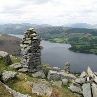
The summit cairn of Arthur's Pike provides a fine viewpoint over the fells surrounding Ullswater, with Helvellyn and Fairfield prominent on the skyline.
-
Howtown to Pooley Bridge
£25.00Learn MoreDifficulty:Exposure:Distance: 17km / 10 milesAscent: 740m / 2500ftDuration: 7 hoursMaximum Group Ratio: 10:1A great linear walk using the Ullswater Steamer, easy terrain and great views over Ullswater throughout
-
Loadpot Hill & Bonscale Pike
£25.00Learn MoreDifficulty:Exposure:Distance: 13km / 8 milesAscent: 530m / 1750 ftDuration: 4-5 hoursMaximum Group Ratio: 10:1Gentle walking on good paths and easy slopes with great views over the northern end of Ullswater
- Price
- Event Type
-
- 01: Diary Walks (2)
- Difficulty
You have no events to compare.






 © 2024 The Lake District Walker Limited. All Rights Reserved.