- Home /
- Routes /
- Far Eastern Fells /
- Wether Hill
Wether Hill


| Grid Reference: | NY 45570 16780 |
| Height: | 670 metres/2198 feet |
| "There is a wide prospect of the Pennines, but undoubtedly the best feature is the finely grouped Helvellyn and Fairfield Fells across the rough, romantic Martindale country." |
|
A.Wainwright
|
North of High Raise on the main High Street ridge the fells become gentler, grassy slopes, turning more towards moorland as they descend towards Penrith and the Eden Valley, the first summit on this ridge is Wether Hill. A lower ridge descends west from Wether Hill, culminating in Steel Knotts.
To the west the ground drops steeply into Fusedale and Martindale but to the east gentle moorland descends towards Bampton and Shap.
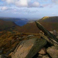
From the northern of the two summits there is a fine view of the Eastern Fells with Martindale in the foreground.
-
Howtown to Pooley Bridge
£25.00Learn MoreDifficulty:Exposure:Distance: 17km / 10 milesAscent: 740m / 2500ftDuration: 7 hoursMaximum Group Ratio: 10:1A great linear walk using the Ullswater Steamer, easy terrain and great views over Ullswater throughout
-
The Martindale Skyline
£25.00Learn MoreDifficulty:Exposure:Distance: 22km / 14 milesAscent: 1300m / 4300ftDuration: 8 hoursMaximum Group Ratio: 10:1A long day but easy walking, wonderful views over Martindale and Ullswater
-
High Street Roman Road
£35.00Learn MoreDifficulty:Exposure:Distance: 37km / 23 milesAscent: 900m / 3000ftDuration: 12 hoursMaximum Group Ratio: 10:1A long walk, similar in difficulty to the Yorkshire 3 Peaks, on good paths throughout
- Price
- Event Type
-
- 01: Diary Walks (2)
- Difficulty
You have no events to compare.






 © 2024 The Lake District Walker Limited. All Rights Reserved.