- Home /
- Routes /
- Far Eastern Fells /
- Harter Fell (Mardale) /
- High Street from Mardale
The huge grassy ridge of High Street is the highest point of the Far Eastern Fells and the grassy slopes give some great ridge walking.
Along the High Street ridge runs a Roman Road, the road between Brougham Fort at Penrith and the fort at Ambleside.
Let our experienced guides take you from Mardale Head at the end of the Haweswater Reservoir on a circuit of these fells with their stunning scenery where we often see Red Deer in the valleys.
Summits included on this route:
Kidsty Pike780 metres / 2559 feet
Rampsgill Head792 metres / 2598 feet
High Street828 metres / 2717 feet
Mardale Ill Bell760 metres / 2493 feet
Harter Fell (Mardale)778 metres / 2552 feet
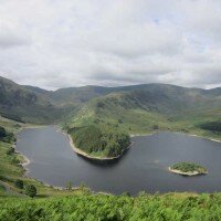
From Mardale Head, by the Haweswater Reservoir we will follow the path along the northern shore of Haweswater, crossing the foot of the Riggindale Valley, stopping at the RSPB hut to look for the Golden Eagle before climbing the long grassy slope to the summit of Kidsty Pike, a wonderful viewpoint over Riggindale.
From Kidsty Pike it's just a short walk to the second summit of the day, Rampsgill Head with magnificent views over Rampsgill and down to Martindale.
After a short descent from Rampsgill Head we will cross the Straits of Riggindale, the head of the Riggindale Valley before the grassy climb to the summit of High Street, the highest of the Far Eastern Fells.
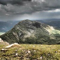
A short walk along the gentle ridge and we will descend to Mardale Ill Bell and cross Nan Bield Pass, with it's unique wind shelter before the final climb of the day, to the summit of Harter Fell, a broad grassy summit.
A short descent from Harter Fell over Adam Seat will bring us to Gatesgarth Pass and a good track dropping back down to Mardale Head.
Each participant will be required to bring suitable equipment for their chosen event, please see Kit List tab above.
Where to meet: Mardale Head Car Park
Postcode: CA10 2RP
Grid Reference: NY 469 107
Directions
From Penrith: Follow the A6 south from Penrith passing through Eamont Bridge, at thee far end of the village turn right, signposted to Ullswater (B5320). Follow this road a short distance until just after crossing the railway line turn left, signposted to Askham. Follow this road though Bampton and Bampton Grange and follow the signs for Haweswater.
Follow the road alongside the lakeshore to a car park at the far end of the lake, we will meet here.
From Shap: Leave Shap on Pow Lane, take the 2nd right turn and follow road to Bampton Grange. Turn left in Bampton Grange and follow the signs for Haweswater.
Follow the road alongside the lakeshore to a car park at the far end of the lake, we will meet here.
Bus Services
There is no bus service to Mardale Head.
Stagecoach bus timetables can be viewed here
Each participant is expected to bring suitable personal equipment for the event.
This should include the following:
Summer Events:
(November - March)
- Walking shoes / Boots
- Waterproof clothing (Jacket and trousers)
- Suitable clothing for walking (no jeans)
- Warm tops
- Packed lunch
- Spare clothing
- Water
- Hat
- Gloves
Winter Events:
(April - October)
- Walking Boots
- Waterproof clothing (Jacket and trousers)
- Suitable clothing for walking (no jeans)
- Warm tops
- Packed lunch
- Spare clothing
- Water
- Hat
- Gloves
- Torch (preferably a headtorch)
- Spare batteries for the above
- Spare Gloves
- Flask & Hot Drink
The Following equipment may also be useful if owned:
- Snow Goggles
- Gaiters
The following equipment will be provided by The Lake District Walker should winter conditions require:
- Ice Axe
- Crampons
-
High Street From Mardale Review by Sue
Overall Experience Can I just let you know what a fabulous guide you have in Kathryn. Such a hot day yesterday and I struggled! She got me up the long pull up Kidsty with great patience and good humour and boy was it worth it once on the tops. Her knowledge of the surrounding views was second to none but most of all just what a lovely person. Ali and both said on the way home it was as though we had just gone out for a days walking with a good friend. She’s a credit to your business! Please ask her to let us know when she achieves her Bob Graham goal we’d love to know she’s done it! (Posted on 03/07/2018)
Use spaces to separate tags. Use single quotes (') for phrases.
Questions:
Question:
Is there a minimum number of participants for this event to go ahead?
Answers:
-
Posted by John Scadding on Thursday, 9 November 2017No, there is no minimum number for this event, if 1 person books then it will go ahead
Question:
What is the minimum age for children on this event?
Answers:
-
Posted by John Scadding on Thursday, 12 October 2017
We do not have a set minimum age for this event, however, you know your child best, therefore please bear in mind this is an open event of varying ages, if you are not confident your child can complete this event then hiring a private guide could be a more suitable option.
As this is an open event all under 18's must be accompanied by an adult.
Question:
What happens if the weather is bad?
Answers:
-
Posted by John Scadding on Thursday, 12 October 2017
We plan to walk whatever the weather, unless it is dangerous to do so.
Mountain weather can be a little unpredictable, but we do keep an eye on the forecasts leading up to walks, should the forecast mean that the walk is not possible then we will contact you as soon as we have the forecast and offer you the following options:
- A more suitable walk on the same date taking into consideration the weather conditions
- A transfer to the same walk on another date
- A full refund
Question:
Are dogs allowed on this walk?
Answers:
-
Posted by John Scadding on Tuesday, 12 September 2017
Yes, dogs are allowed on all our walks.
However we do cross farmland and common land where animals will be grazing, there will be large sections of the walk, if not all, where dogs will be required to be on a lead.
Please login to your account to post a question





 © 2024 The Lake District Walker Limited. All Rights Reserved.