- Home /
- Routes /
- Western Fells /
- Great Gable /
- Great Gable & Haystacks
A wonderful route climbing Great Gable from the Buttermere Valley, taking in the summits of Haystacks, Green Gable, Brandreth, Grey Knotts and Fleetwith Pike, one of the most spectacular ways of climbing Great Gable with stunning and varied views throughout.
Summits included on this route:
Haystacks597 metres / 1959 feet
Great Gable899 metres / 2949 feet
Green Gable801 metres / 2628 feet
Brandreth715 metres / 2346 feet
Grey Knotts679 metres / 2287 feet
Fleetwith Pike648 metres / 2126 feet
Starting at Gatesgarth Farm we cross the fields to climb the good path to Scarth Gap, the pass between Buttermere and Ennerdale, from here we turn onto the ridge to climb to the rocky summit of Haystacks. A wonderful rocky mountain with great views of the higher Mountains on all sides.
From the summit of Haystacks we will follow the ridge east around several of the lesser tops, taking time to find all the best views of the surrounding land and taking in some of the tarns along the ridge, including Innominate Tarn, the final resting place of Alfred Wainwright.
From Innominate Tarn we continue to the equally picturesque Blackbeck Tarn before taking the path up alongside Great Round How to climb by the fence to the Moses Trod path, an old smugglers route that takes us across the fellside above the head of the Ennerdale Valley, with stunning views out to the Solway Coast.
The Moses Trod path brings us gently up to Beck Head, the pass between Great Gable and Kirk Fell, here we will have our first views down the Wasdale Valley to Wastwater, on a good day we can see the Isle of Man from here.
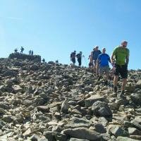
From Beck Head our route climbs steeply to the summit of Great Gable, a few easy rocky scrambles will bring us up onto the summit of Great Gable.
On a good day it's well worth the slight detour from the summit of Great Gable to take in the Westmorland Cairn, one of the best views in the Lake District and a great spot for lunch.
Back over the summit of Great Gable and we take the path descending towards Windy Gap, a rocky short descent will bring us down onto the red rock of Windy Gap and the short climb to the summit of of Green Gable.
The views from Green Gable to Great Gable can be spectacular, with the summit towering above us and a great view of Gable Crag, the view down the length of the Ennerdale Valley is equally spectacular.
From Green Gable the path continues down to Gillercombe Head and then the easy ascent up onto Brandreth.
From Brandreth the route follows the fenceline to the summit of Grey Knotts, with barely any ascent to Grey Knotts take the time to admire the wonderful views to the west, over Buttermere and Crummock Water to the Solway Coast beyond.
From Grey Knotts we will descend to the north west to drop down onto the Moses Trod path again, following the track down to the Drum House, crossing the tramway to climb up by the Honister Quarries to meet the ridge by Black Star and follow it along to the summit of Fleetwith Pike.
From Fleetwith Pike we descend west, dropping down Fleetwith Edge, a spectacular descent with the views down towards Buttermere and Crummock Water ever changing as we descend the ridge by Low Raven Crag and then down by the war memorial to the roadside just above Gatesgarth Farm.
Each participant will be required to bring suitable equipment for their chosen event, please see Kit List tab above.
Where to meet: Gatesgarth Farm, Buttermere
Postcode: CA13 9XA
Grid Reference: NY 194 149
Directions
From Keswick: Leave Keswick on the Borrowdale Road (from the mini roundabout near the co-op) Follow this road for approx 8 miles, passing through Rosthwaite to the village of Seatoller, from here the road climbs over Honister Pass, descend the eastern slopes of the pass to Gatesgarth Farm, a car park will be seen on the opposite side of the road from the farm, there is a charge for this car park. We will meet by the bridge.
From Cockermouth: Leave Cockermouth on the Lorton Road, leaving town opposite Sainsburys. Follow this road through the village of Low Lorton and continue until a road leads to the left, signposted for Buttermere, follow this road and continue past Buttermere. After the road passes alongside the lake a farm will be reached on the right, park in the car park opposite (there is a charge for this car park), we will meet by the bridge.
Bus Services
The 77 / 77a bus stops at Gatesgarth Farm, right opposite the meet point..
The 77 / 77a runs from Keswick to Buttermere over Honister Pass and Whinlatter.
Stagecoach bus timetables can be viewed here
Each participant is expected to bring suitable personal equipment for the event.
This should include the following:
Summer Events:
(November - March)
- Walking shoes / Boots
- Waterproof clothing (Jacket and trousers)
- Suitable clothing for walking (no jeans)
- Warm tops
- Packed lunch
- Spare clothing
- Water
- Hat
- Gloves
Winter Events:
(April - October)
- Walking Boots
- Waterproof clothing (Jacket and trousers)
- Suitable clothing for walking (no jeans)
- Warm tops
- Packed lunch
- Spare clothing
- Water
- Hat
- Gloves
- Torch (preferably a headtorch)
- Spare batteries for the above
- Spare Gloves
- Flask & Hot Drink
The Following equipment may also be useful if owned:
- Snow Goggles
- Gaiters
The following equipment will be provided by The Lake District Walker should winter conditions require:
- Ice Axe
- Crampons
Use spaces to separate tags. Use single quotes (') for phrases.
Questions:
Question:
What is the minimum age for children on this event?
Answers:
-
Posted by John Scadding on Friday, 13 October 2017
We do not have a set minimum age for this event, however, you know your child best, therefore please bear in mind this is an open event of varying ages, if you are not confident your child can complete this event then hiring a private guide could be a more suitable option.
As this is an open event all under 18's must be accompanied by an adult.
Question:
What happens if the weather is bad?
Answers:
-
Posted by John Scadding on Thursday, 12 October 2017
We plan to walk whatever the weather, unless it is dangerous to do so.
Mountain weather can be a little unpredictable, but we do keep an eye on the forecasts leading up to walks, should the forecast mean that the walk is not possible then we will contact you as soon as we have the forecast and offer you the following options:
- A more suitable walk on the same date taking into consideration the weather conditions
- A transfer to the same walk on another date
- A full refund
Question:
Are dogs allowed on this walk?
Answers:
-
Posted by John Scadding on Friday, 22 September 2017
Yes, dogs are allowed on all our walks.
However we do cross farmland and common land where animals will be grazing, there will be large sections of the walk, if not all, where dogs will be required to be on a lead.
There are sections of this walk across rough ground and boulders and as such this walk may not be suitable for all dogs.
Please login to your account to post a question



 © 2024 The Lake District Walker Limited. All Rights Reserved.